
File:Rekareka map.jpg

Size of this preview: 800 × 583 pixels. Other resolutions: 320 × 233 pixels | 640 × 467 pixels | 1,024 × 747 pixels | 1,240 × 904 pixels.
Original file (1,240 × 904 pixels, file size: 333 KB, MIME type: image/jpeg)
| This is a file from the Wikimedia Commons. Information from its description page there is shown below. Commons is a freely licensed media file repository. You can help. |

|
This map image could be re-created using vector graphics as an SVG file. This has several advantages; see Commons:Media for cleanup for more information. If an SVG form of this image is available, please upload it and afterwards replace this template with
{{vector version available|new image name}}.
It is recommended to name the SVG file “Rekareka map.svg”—then the template Vector version available (or Vva) does not need the new image name parameter. |


Summary
| Description |
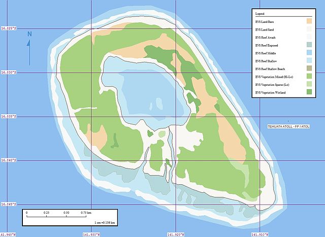
Català: Mapa de l'atol Rekareka o Tehuata (arxipèlag Tuamotu, Polinèsia Francesa).
English: Map of Rekareka or Tehuata (Tuamotu Archipelago, French Polynesia). |
| Date | |
| Source | Tehuata Atoll - Marplot Map (1-15,625) |
| Author | Mr Minton from San Diego, US |
Licensing
This file is licensed under the Creative Commons Attribution 2.0 Generic license.
- You are free:
- to share – to copy, distribute and transmit the work
- to remix – to adapt the work
- Under the following conditions:
- attribution – You must give appropriate credit, provide a link to the license, and indicate if changes were made. You may do so in any reasonable manner, but not in any way that suggests the licensor endorses you or your use.
| This image was originally posted to Flickr by EVS-Islands at https://www.flickr.com/photos/60042877@N00/302581117. It was reviewed on 15 June 2008 by FlickreviewR and was confirmed to be licensed under the terms of the cc-by-2.0. |
File history
Click on a date/time to view the file as it appeared at that time.
| Date/Time | Thumbnail | Dimensions | User | Comment | |
|---|---|---|---|---|---|
| current | 12:03, 15 June 2008 | | 1,240 × 904 (333 KB) | Vriullop | {{Information |Description= {{ca|Mapa de l'atol Rekareka o Tehuata (arxipèlag Tuamotu, Polinèsia Francesa).}} {{en|Map of Rekareka or Tehuata (Tuamotu Archipelago, French Polynesia).}} |Source=[http://www.flickr.com/photos/60042877@N00/302581117/ Tehua |
File usage
The following pages on the English Wikipedia use this file (pages on other projects are not listed):
Global file usage
The following other wikis use this file:
- Usage on az.wikipedia.org
- Usage on ca.wikipedia.org
- Usage on ceb.wikipedia.org
- Usage on de.wikipedia.org
- Usage on es.wikipedia.org
- Usage on fr.wikipedia.org
- Usage on gl.wikipedia.org
- Usage on it.wikipedia.org
- Usage on nl.wikipedia.org
- Usage on pt.wikipedia.org
- Usage on ru.wikipedia.org
- Usage on sk.wikipedia.org
- Usage on sw.wikipedia.org
- Usage on www.wikidata.org
- Usage on zh.wikipedia.org