
File:Rail Tracks map Meitetsu Central Japan Int'l Airport Stn.svg

Size of this PNG preview of this SVG file: 360 × 150 pixels. Other resolutions: 320 × 133 pixels | 640 × 267 pixels | 1,024 × 427 pixels | 1,280 × 533 pixels | 2,560 × 1,067 pixels.
Original file (SVG file, nominally 360 × 150 pixels, file size: 5 KB)
| This is a file from the Wikimedia Commons. Information from its description page there is shown below. Commons is a freely licensed media file repository. You can help. |
| Description |
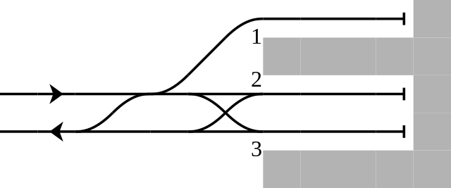
English: Rail tracks map of Nagoya Railroad Central Japan International Airport Station in Tokoname, Aichi Pref., Japan.
Reference material: DENKISHA KENKYUKAI, "THE RAILWAY PICTORIAL" Vol.816, Extra edition - "名古屋鉄道(Nagoya Railroad)" insert page at end, 2009-03
日本語: 愛知県常滑市にある名古屋鉄道中部国際空港駅構内配線略図
参考文献:電気車研究会、『鉄道ピクトリアル』通巻第816号 2009年3月 臨時増刊号 「特集 - 名古屋鉄道」、巻末折込「名古屋鉄道 配線略図」 凡例は駅配線図テンプレートを参照Français : Plan de voies |
||
| Date | |||
| Source | Tawashi2006 created from icons in Category:Rail_tracks_map_template. | ||
| Author | Tawashi2006 with pdv2svg | ||
| Permission (Reusing this file) |
|
File history
Click on a date/time to view the file as it appeared at that time.
| Date/Time | Thumbnail | Dimensions | User | Comment | |
|---|---|---|---|---|---|
| current | 12:48, 10 April 2009 | | 360 × 150 (5 KB) | Tawashi2006 | {{Information |Description = {{en|1=Rail tracks map of Nagoya Railroad '''Central Japan International Airport Station''' in Tokoname, Aichi Pref., Japan. Reference material: DENKISHA |
File usage
The following pages on the English Wikipedia use this file (pages on other projects are not listed):
Global file usage
The following other wikis use this file:
- Usage on de.wikipedia.org
- Usage on ja.wikipedia.org
- Usage on www.wikidata.org
- Usage on zh.wikipedia.org