
File:Palacio de Miraflores (Madrid) 01.jpg

Size of this preview: 495 × 600 pixels. Other resolutions: 198 × 240 pixels | 396 × 480 pixels | 634 × 768 pixels | 845 × 1,024 pixels | 1,690 × 2,048 pixels | 3,240 × 3,925 pixels.
Original file (3,240 × 3,925 pixels, file size: 1.93 MB, MIME type: image/jpeg)
| This is a file from the Wikimedia Commons. Information from its description page there is shown below. Commons is a freely licensed media file repository. You can help. |
This is a photo of a monument indexed in the Spanish heritage register of Bienes de Interés Cultural under the reference RI-51-0004231. |
| Description |
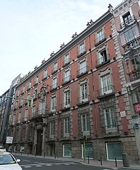
English: Façade of the Palace of the marquis of Miraflores, at 19 Carrera de San Jerónimo (street) in Centro district in Madrid (Spain). Building projected by Pedro de Ribera and built from 1731 to 1732. It was reformed by Joaquin Sainz de los Terreros Gómez in the 1945 for the Insurance Company Hispano Americana Atlantide.
Español: Fachada del Palacio del marqués de Miraflores, en el nº 19 de la Carrera de San Jerónimo de Madrid (España), en el distrito Centro. Edificio proyectado por Pedro de Ribera y construido de 1731 a 1732. Fue reformado por Joaquin Sainz de los Terreros Gómez en el 1945 para la Compania Hispano Americana de Seguros Atlantide. De la inauguración da cuenta el periódico ABC del 31.1.1946 (pág.18). |
||
| Date | |||
| Source | Own work | ||
| Author | Luis García (Zaqarbal) | ||
| Permission (Reusing this file) |
I, the copyright holder of this work, hereby publish it under the following licenses:
This file is licensed under the Creative Commons Attribution-Share Alike 3.0 Unported, 2.5 Generic, 2.0 Generic and 1.0 Generic license. Attribution: Luis García
You may select the license of your choice. |

_01.jpg)
| Object location | | View this and other nearby images on: OpenStreetMap |
|---|
_01.jpg¶ms=040.416641_N_-003.699108_E_globe:Earth_class:object_type:landmark_region:ES_&language=en)
File history
Click on a date/time to view the file as it appeared at that time.
| Date/Time | Thumbnail | Dimensions | User | Comment | |
|---|---|---|---|---|---|
| current | 03:50, 1 May 2011 | | 3,240 × 3,925 (1.93 MB) | Zaqarbal | Photo taken by Luis García (Zaqarbal) on April 30, 2011. Hereby published under GFDL and Cc-by-sa-3.0,2.5,2.0,1.0 licenses. |
File usage
The following pages on the English Wikipedia use this file (pages on other projects are not listed):
Global file usage
The following other wikis use this file:
- Usage on es.wikipedia.org
_01.jpg)