
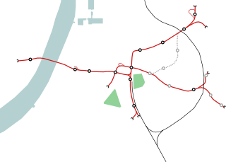
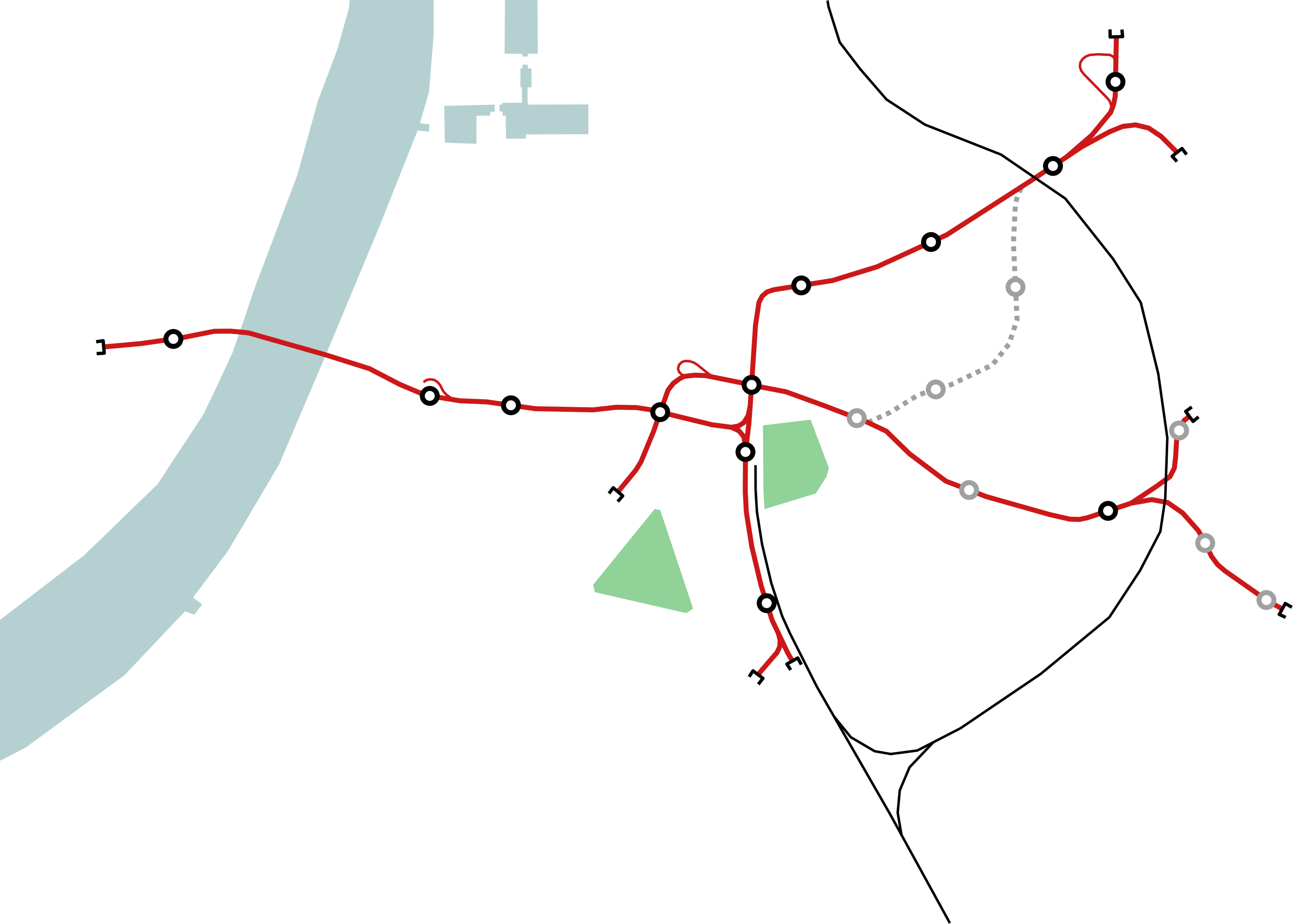
File:Outline map Antwerp premetro.svg

Size of this PNG preview of this SVG file: 520 × 372 pixels. Other resolutions: 320 × 229 pixels | 640 × 458 pixels | 1,024 × 733 pixels | 1,280 × 916 pixels | 2,560 × 1,831 pixels.
Original file (SVG file, nominally 520 × 372 pixels, file size: 22 KB)
| This is a file from the Wikimedia Commons. Information from its description page there is shown below. Commons is a freely licensed media file repository. You can help. |
Summary
| Description | |
| Date | 2007, 2015, 2018 |
| Source |
Own work This vector image was created with Inkscape . |
| Author | Michiel1972 |
Licensing
I, the copyright holder of this work, hereby publish it under the following licenses:

|
Permission is granted to copy, distribute and/or modify this document under the terms of the GNU Free Documentation License, Version 1.2 or any later version published by the Free Software Foundation; with no Invariant Sections, no Front-Cover Texts, and no Back-Cover Texts. A copy of the license is included in the section entitled GNU Free Documentation License. |
This file is licensed under the Creative Commons Attribution-Share Alike 3.0 Unported, 2.5 Generic, 2.0 Generic and 1.0 Generic license.
- You are free:
- to share – to copy, distribute and transmit the work
- to remix – to adapt the work
- Under the following conditions:
- attribution – You must give appropriate credit, provide a link to the license, and indicate if changes were made. You may do so in any reasonable manner, but not in any way that suggests the licensor endorses you or your use.
- share alike – If you remix, transform, or build upon the material, you must distribute your contributions under the same or compatible license as the original.
You may select the license of your choice.
File history
Click on a date/time to view the file as it appeared at that time.
| Date/Time | Thumbnail | Dimensions | User | Comment | |
|---|---|---|---|---|---|
| current | 23:27, 3 June 2018 | | 520 × 372 (22 KB) | Squizie3 | Update for better visibility on smaller resolutions (the 260px infoboxes where this file is used for) |
| 23:39, 2 June 2018 |  | 970 × 694 (22 KB) | Squizie3 | Added stations (and some other small visual tweaks) | |
| 22:57, 2 June 2018 |  | 970 × 694 (16 KB) | Squizie3 | Update (extra tunnelsegmenten in gebruik) | |
| 00:53, 24 April 2015 |  | 909 × 651 (15 KB) | Wester | I | |
| 00:35, 24 April 2015 |  | 909 × 651 (15 KB) | Wester | I | |
| 00:33, 24 April 2015 |  | 909 × 651 (15 KB) | Wester | i | |
| 14:54, 17 August 2007 |  | 870 × 850 (10 KB) | Michiel1972 | ||
| 14:39, 17 August 2007 |  | 870 × 850 (10 KB) | Michiel1972 | corr. | |
| 14:33, 17 August 2007 |  | 870 × 850 (10 KB) | Michiel1972 | ||
| 13:32, 17 August 2007 |  | 850 × 850 (31 KB) | Michiel1972 |
File usage
The following pages on the English Wikipedia use this file (pages on other projects are not listed):
- Antwerp Pre-metro
- Astrid (Antwerp premetro station)
- Diamant (Antwerp premetro station)
- Elisabeth (Antwerp premetro station)
- Groenplaats (Antwerp premetro station)
- Handel (Antwerp premetro station)
- Meir premetro station
- Opera (Antwerp premetro station)
- Plantin premetro station
- Schijnpoort (Antwerp premetro station)
- Sport (Antwerp premetro station)
- Van Eeden (Antwerp premetro station)
- Zegel (Antwerp premetro station)
- User:Cinoreros/sandbox/Schijnpoort (Antwerp premetro station)
- Module:Location map/data/Antwerp premetro
- Module:Location map/data/Belgium Antwerp premetro
- Module:Location map/data/Belgium Antwerp premetro/doc
Global file usage
The following other wikis use this file:
- Usage on ar.wikipedia.org
- Usage on es.wikipedia.org
- Usage on mr.wikipedia.org
- Usage on nl.wikipedia.org
- Antwerpse tram
- Antwerpse premetro
- Meir (premetrostation)
- Groenplaats (premetrostation)
- Opera (premetrostation)
- Van Eeden (premetrostation)
- Astrid (premetrostation)
- Elisabeth (premetrostation)
- Handel (premetrostation)
- Diamant (premetrostation Antwerpen)
- Sport (premetrostation)
- Schijnpoort (premetrostation)
- Plantin (premetrostation)
- Drink (premetrostation)
- Zegel (premetrostation)
- Foorplein (premetrostation)
- Carnot (premetrostation)
- Sint-Willibrordus (premetrostation)
- Stuivenberg (premetrostation)
- Morckhoven (premetrostation)
- Collegelaan (premetrostation)
- Sjabloon:Positiekaart premetrostation Antwerpen
- Sjabloon:Infobox premetrostation Antwerpen
- Usage on ro.wikipedia.org
- Premetroul din Antwerpen
- Groenplaats (stație de premetrou din Antwerpen)
- Astrid (stație de premetrou din Antwerpen)
- Format:Harta de localizare Premetroul din Antwerpen
- Plantin (stație de premetrou din Antwerpen)
- Diamant (stație de premetrou din Antwerpen)
- Elisabeth (stație de premetrou din Antwerpen)
- Handel (stație de premetrou din Antwerpen)
- Schijnpoort (stație de premetrou din Antwerpen)
- Sport (stație de premetrou din Antwerpen)
- Meir (stație de premetrou din Antwerpen)
- Stuivenberg (stație de premetrou din Antwerpen)
- Sint-Willibrordus (stație de premetrou din Antwerpen)
- Opera (stație de premetrou din Antwerpen)
- Van Eeden (stație de premetrou din Antwerpen)
- Foorplein (stație de premetrou din Antwerpen)
- Collegelaan (stație de premetrou din Antwerpen)
- Carnot (stație de premetrou din Antwerpen)
- Morckhoven (stație de premetrou din Antwerpen)
- Drink (stație de premetrou din Antwerpen)
- Zegel (stație de premetrou din Antwerpen)
View more global usage of this file.