
File:Michael Airfield.jpg

Size of this preview: 800 × 499 pixels. Other resolutions: 320 × 200 pixels | 640 × 399 pixels | 954 × 595 pixels.
Original file (954 × 595 pixels, file size: 120 KB, MIME type: image/jpeg)
| This is a file from the Wikimedia Commons. Information from its description page there is shown below. Commons is a freely licensed media file repository. You can help. |
Summary
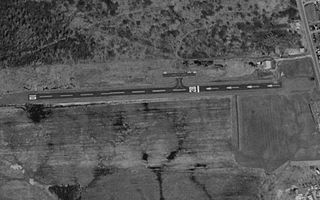
| Description | Aerial image of Michael Airfield in Cicero, New York, United States |
| Date | |
| Source | United States Geological Survey via TerraServer-USA |
| Author | USGS |
| Permission (Reusing this file) |
Public domain |
Licensing
This image is in the public domain in the United States because it only contains materials that originally came from the United States Geological Survey, an agency of the United States Department of the Interior. For more information, see the official USGS copyright policy.
|
File history
Click on a date/time to view the file as it appeared at that time.
| Date/Time | Thumbnail | Dimensions | User | Comment | |
|---|---|---|---|---|---|
| current | 01:51, 12 June 2009 | | 954 × 595 (120 KB) | AuburnPilot | == Summary == {{Information |Description=Satellite image of Michael Airfield on 27 March 1995 |Source=United States Geological Survey, TerraServer-USA |Date=1995-03-27 |Author=USGS |Permission=Public domain |other_versions= }} [[Category:Airports in New Y |
File usage
The following pages on the English Wikipedia use this file (pages on other projects are not listed):
Global file usage
The following other wikis use this file:
- Usage on fa.wikipedia.org
- Usage on tg.wikipedia.org
- Usage on ur.wikipedia.org
- Usage on www.wikidata.org