
File:LageRungholt.png
No higher resolution available.
LageRungholt.png (600 × 400 pixels, file size: 62 KB, MIME type: image/png)
| This is a file from the Wikimedia Commons. Information from its description page there is shown below. Commons is a freely licensed media file repository. You can help. |
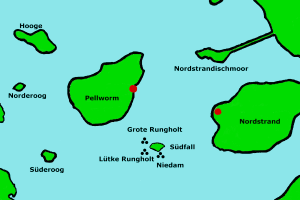
Summary
| Description |
Deutsch: Karte der archäologischen Fundorte Rungholts bei der Hallig Südfall. Eigene Grafik, steht hiermit unter GNU-FDL. |
| Date | 15 November 2004 (original upload date) |
| Source | Transferred from de.wikipedia to Commons by Ireas using CommonsHelper. |
| Author | The original uploader was Unscheinbar at German Wikipedia. |
Licensing

|
Permission is granted to copy, distribute and/or modify this document under the terms of the GNU Free Documentation License, Version 1.2 or any later version published by the Free Software Foundation; with no Invariant Sections, no Front-Cover Texts, and no Back-Cover Texts. A copy of the license is included in the section entitled GNU Free Documentation License. |
Original upload log
The original description page was here. All following user names refer to de.wikipedia.
- 2010-10-05 17:04 Bonzo* 600×400× (63095 bytes) {{Information |Beschreibung = Karte der archäologischen Fundorte Rungholts bei der Hallig Südfall. Eigene Grafik, steht hiermit unter GNU-FDL. |Quelle = [[Benutzer:Unscheinbar|Unscheinbar]], [http://de.wikipedia.org/w/index.php?title=Datei:LageRungholt.png&diff=prev&oldid=4659958 Version vom 15. November 2004, 12:18 Uhr] |Urheber = [[Benutzer:Bonzo*|Bonzo*]] |Datum = 5. Oktober 2010 |Genehmigung = |Andere Versionen = |Anmerkungen = weniger grelle Farben }} {{Bild-GFDL}} {{In SVG konvertieren|Geografie}}
- 2004-11-15 11:18 Unscheinbar 600×400× (54824 bytes) Karte der archäologischen Fundorte Rungholts bei der Hallig Südfall. Eigene Grafik, steht hiermit unter GNU-FDL.
File history
Click on a date/time to view the file as it appeared at that time.
| Date/Time | Thumbnail | Dimensions | User | Comment | |
|---|---|---|---|---|---|
| current | 01:29, 7 October 2010 | | 600 × 400 (62 KB) | File Upload Bot (Magnus Manske) | {{BotMoveToCommons|de.wikipedia|year={{subst:CURRENTYEAR}}|month={{subst:CURRENTMONTHNAME}}|day={{subst:CURRENTDAY}}}} {{Information |Description={{de|Karte der archäologischen Fundorte Rungholts bei der Hallig Südfall. Eigene Grafik, steht hiermit unt |
File usage
The following pages on the English Wikipedia use this file (pages on other projects are not listed):
Global file usage
The following other wikis use this file:
- Usage on da.wikipedia.org
- Usage on de.wikipedia.org
- Usage on frr.wikipedia.org
- Usage on it.wikipedia.org
- Usage on ru.wikipedia.org