
File:Keem Bay, Achill Island Co. Mayo, Ireland - geograph.org.uk - 683771.jpg
No higher resolution available.
Keem_Bay,_Achill_Island_Co._Mayo,_Ireland_-_geograph.org.uk_-_683771.jpg (640 × 213 pixels, file size: 49 KB, MIME type: image/jpeg)
| This is a file from the Wikimedia Commons. Information from its description page there is shown below. Commons is a freely licensed media file repository. You can help. |
Summary
| Description |
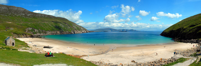
English: Keem Bay, Achill Island Co. Mayo, Ireland Keem Bay on Achill Island, (Acaill, Oileán Acla) County Mayo in Ireland is a perfect horseshoe bay containing a popular Blue Flag beach at the head of a valley between the cliffs of Benmore to the west and Croaghaun mountain on the east. At the southern end of the valley, the beach is sheltered to the west by Moyteoge Head, while at the northwestern end of the valley the cliffs of Benmore connect with the spectacular mile long promontory of Achill Head. This spar is the most westerly point on Achill and tails off with two sea stacks called Gaoí Saggart and Carrickakin. Keem is accessible for cars via a clifftop road that was constructed in the 1960s along the route of an older track. This road also crosses a local geological boundary, exposing a seam of amethyst quartz in the cliffside. Amethyst is a semiprecious stone with a magnificent purple to voilet coloration, said in folklore to have a number of properties including as a love charm, as protection against thieves and drunkeness, and as an aide to sleep. Keem Bay was traditionally used by fishermen on Achill Island and is undoubtedly the location of the artist Paul Henry's famous painting 'Launching the Currach' (1910, on display in the National Gallery of Ireland). Until fairly recently the waters of Keem Bay were home to the basking shark as well as grey seals and numerous varieties of fish. In the 1940s and 50s the basking shark was hunted by local fishermen at Keem Bay using traditional canvas covered curraghs and directed by spotters situated on the cliffside on Moyteoge Head. The oil of the basking shark was extracted for export as a fine grade lubricant for the aerospace industry. The largest specimen of the porbeagle shark caught by rod-and-line in Irish waters was caught off Keem Bay by Dr. O'Donnell-Browne in 1932. It weighed 365lbs. Croaghaun is the most westerly peak of Achill Island and stands at 664 metres. On the northern slope of the mountain lie the highest sea cliffs in the country and also the highest in Europe. The cliffs are part of a vast array of sheer rock faces which start south of Keem Bay and loop around Achill head onwards to Slievemore, dropping almost vertically into the pounding waters of the Atlantic Ocean. |
| Date | |
| Source | From geograph.org.uk |
| Author | Mike Shinners |
| Attribution (required by the license) | Mike Shinners / Keem Bay, Achill Island Co. Mayo, Ireland / |
| Camera location | | View this and other nearby images on: OpenStreetMap |
|---|
_heading:135.00&language=en)
| Object location | | View this and other nearby images on: OpenStreetMap |
|---|
_heading:135.00&language=en)
Licensing

|
This image was taken from the Geograph project collection. See this photograph's page on the Geograph website for the photographer's contact details. The copyright on this image is owned by Mike Shinners and is licensed for reuse under the Creative Commons Attribution-ShareAlike 2.0 license.
|
This file is licensed under the Creative Commons Attribution-Share Alike 2.0 Generic license.
Attribution: Mike Shinners
- You are free:
- to share – to copy, distribute and transmit the work
- to remix – to adapt the work
- Under the following conditions:
- attribution – You must give appropriate credit, provide a link to the license, and indicate if changes were made. You may do so in any reasonable manner, but not in any way that suggests the licensor endorses you or your use.
- share alike – If you remix, transform, or build upon the material, you must distribute your contributions under the same or compatible license as the original.
File history
Click on a date/time to view the file as it appeared at that time.
| Date/Time | Thumbnail | Dimensions | User | Comment | |
|---|---|---|---|---|---|
| current | 01:53, 8 February 2011 | 640 × 213 (49 KB) | GeographBot | == {{int:filedesc}} == {{Information |description={{en|1=Keem Bay, Achill Island Co. Mayo, Ireland Keem Bay on Achill Island, (Acaill, Oileán Acla) County Mayo in Ireland is a perfect horseshoe bay containing a popular Blue Flag beach at the head of a va |
File usage
The following pages on the English Wikipedia use this file (pages on other projects are not listed):