
File:Holm totem pole - geograph.org.uk - 1340213.jpg
Size of this preview: 400 × 600 pixels. Other resolutions: 160 × 240 pixels | 427 × 640 pixels.
Original file (427 × 640 pixels, file size: 70 KB, MIME type: image/jpeg)
| This is a file from the Wikimedia Commons. Information from its description page there is shown below. Commons is a freely licensed media file repository. You can help. |
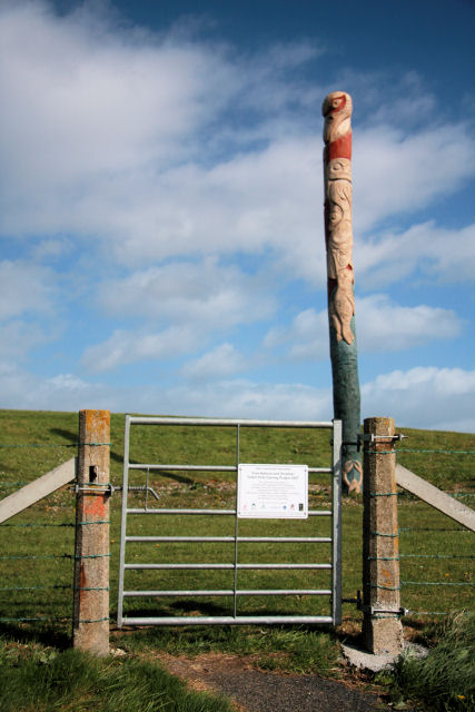
Summary
| Description |
English: Holm totem pole This totem pole was put into position on 29 September 2007. Canadian carvers from the Squamish First Nations region had travelled to the Orkney Mainland to work with local people to produce this unusual piece of artwork for the Holm community.
The carvers met local schoolchildren and members of the community who then helped to design and carve the 10m high pole. It was erected in the corner of the new sports field directly in line with the end of the first Churchill Barrier. |
| Date | |
| Source | From geograph.org.uk |
| Author | Bob Jones |
| Attribution (required by the license) | Bob Jones / Holm totem pole / |
| Camera location | | View this and other nearby images on: OpenStreetMap |
|---|
_heading:0.00&language=en)
| Object location | | View this and other nearby images on: OpenStreetMap |
|---|
_heading:0.00&language=en)
Licensing

|
This image was taken from the Geograph project collection. See this photograph's page on the Geograph website for the photographer's contact details. The copyright on this image is owned by Bob Jones and is licensed for reuse under the Creative Commons Attribution-ShareAlike 2.0 license.
|
This file is licensed under the Creative Commons Attribution-Share Alike 2.0 Generic license.
Attribution: Bob Jones
- You are free:
- to share – to copy, distribute and transmit the work
- to remix – to adapt the work
- Under the following conditions:
- attribution – You must give appropriate credit, provide a link to the license, and indicate if changes were made. You may do so in any reasonable manner, but not in any way that suggests the licensor endorses you or your use.
- share alike – If you remix, transform, or build upon the material, you must distribute your contributions under the same or compatible license as the original.
File history
Click on a date/time to view the file as it appeared at that time.
| Date/Time | Thumbnail | Dimensions | User | Comment | |
|---|---|---|---|---|---|
| current | 04:45, 28 February 2011 | | 427 × 640 (70 KB) | GeographBot | == {{int:filedesc}} == {{Information |description={{en|1=Holm totem pole This totem pole was put into position on 29 September 2007. Canadian carvers from the Squamish First Nations region had travelled to the Orkney Mainland to work with local people to |
File usage
The following pages on the English Wikipedia use this file (pages on other projects are not listed):