File:Expanded Visayas.png

Page contents not supported in other languages.
This is a file from the Wikimedia Commons
From Wikipedia, the free encyclopedia

Original file(963 × 963 pixels, file size: 110 KB, MIME type: image/png)

Summary

Description

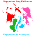
Hiligaynon: Mapa sang Kapupud-an sang Kabisay-an.

Mga Rehiyon:

  • Katundanon nga Kabisay-an + Masbate kag Romblon
  • Ang Rehiyon sang Pulo sang Negros
  • Tunga-Tunga nga Kabisay-an
  • Sidlanganon nga Kabisay-an/Ang Kapupud-an sang Samar-Leyte
Cebuano: Mapa sang Kapupud-an sa Kabisay-an.

Mga Rehiyon:

  • Kasadpang Kabisay-an + Masbate ug Romblon
  • Ang Rehiyon sa Pulo sa Negros
  • Tunga-Tungang Kabisay-an
  • Sidlakang Kabisay-an/Ang Kapupud-an sa Samar-Leyte
English: Map of the Archipelago of Visayas.

The Regions:

  • Western Visayas + Masbate and Romblon
  • The Negros Island Region
  • Central Visayas
  • Eastern Visayas/The Samar-Leyte Archipelago
Italiano: Mappa dell'arcipelago di Visayas.

I Regioni:

  • Visayas Occidentale + Masbate e Romblon
  • Il Regione dell'Isola di Negros
  • Visayas Centrale
  • Visayas Orientale/L'Arcipelago di Samar-Leyte
Date
Source Modified derivative work of File:BlankMap-Philippines-ProvinceBorders.png by TheCoffee (Mike Gonzalez)
Author Straight-Outta-Negros-0013

Licensing

I, the copyright holder of this work, hereby publish it under the following license:
w:en:Creative Commons
attribution share alike
This file is licensed under the Creative Commons Attribution-Share Alike 3.0 Unported license.
You are free:
  • to share – to copy, distribute and transmit the work
  • to remix – to adapt the work
Under the following conditions:
  • attribution – You must give appropriate credit, provide a link to the license, and indicate if changes were made. You may do so in any reasonable manner, but not in any way that suggests the licensor endorses you or your use.
  • share alike – If you remix, transform, or build upon the material, you must distribute your contributions under the same or compatible license as the original.

Captions

Add a one-line explanation of what this file represents

Items portrayed in this file

depicts

28 April 2017

File history

Click on a date/time to view the file as it appeared at that time.

Date/TimeThumbnailDimensionsUserComment
current06:20, 17 September 2017Thumbnail for version as of 06:20, 17 September 2017963 × 963 (110 KB)Straight-Outta-Negros-0013Colour change
05:30, 26 August 2017Thumbnail for version as of 05:30, 26 August 2017963 × 963 (108 KB)Straight-Outta-Negros-0013Erased the provincial borders for a wholesome look.
13:30, 29 April 2017Thumbnail for version as of 13:30, 29 April 2017963 × 963 (136 KB)Straight-Outta-Negros-0013Turned the tiniest gray dot into blue for Cebu.
05:21, 28 April 2017Thumbnail for version as of 05:21, 28 April 2017963 × 963 (117 KB)Straight-Outta-Negros-0013User created page with UploadWizard
The following pages on the English Wikipedia use this file (pages on other projects are not listed):

Metadata