
File:Dixon entrance boundary dispute.jpg
Size of this preview: 800 × 431 pixels. Other resolutions: 320 × 173 pixels | 640 × 345 pixels | 1,280 × 690 pixels.
Original file (1,280 × 690 pixels, file size: 117 KB, MIME type: image/jpeg)
| This is a file from the Wikimedia Commons. Information from its description page there is shown below. Commons is a freely licensed media file repository. You can help. |
Summary
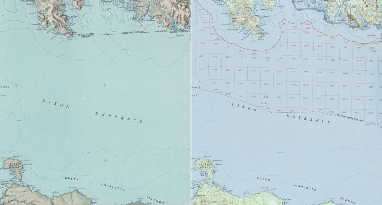
| Description | Dixon Entrance, Northwestern America. An illustration of the boundary dispute by showing the different notions of the U.S.-Canadian boundary on two maps provided by the U.S. Dept. of the Interior Geological Survey (enlarged detail of original material). The left side shows the 1903 AB-Line (dashed line in the upper third) and the right side the U.S. notion of the “limit of exclusive economic zone” (dashed black line near the label ‘Dixon Entrance’). |
| Date | |
| Source | Both source maps are from the US Geological Survey 1:250,000 series of Alaska; available online at the University of Texas Perry-Castañeda Library Map Collection 1959 map (jpg 3.4 MB) 1985 map (jpg 5.4 MB) |
| Author | Carsten Finis |
| Permission (Reusing this file) |
Source Material: http://www.lib.utexas.edu/maps/faq.html#3.html |
Licensing
This work is in the public domain in the United States because it is a work prepared by an officer or employee of the United States Government as part of that person’s official duties under the terms of Title 17, Chapter 1, Section 105 of the US Code.
Note: This only applies to original works of the Federal Government and not to the work of any individual U.S. state, territory, commonwealth, county, municipality, or any other subdivision. This template also does not apply to postage stamp designs published by the United States Postal Service since 1978. (See § 313.6(C)(1) of Compendium of U.S. Copyright Office Practices). It also does not apply to certain US coins; see The US Mint Terms of Use.
|
 | |
| This file has been identified as being free of known restrictions under copyright law, including all related and neighboring rights. | ||
File history
Click on a date/time to view the file as it appeared at that time.
| Date/Time | Thumbnail | Dimensions | User | Comment | |
|---|---|---|---|---|---|
| current | 22:39, 30 November 2007 | | 1,280 × 690 (117 KB) | Pyrokrat~commonswiki | {{Information |Description=Dixon Entrance, Northwestern America. An illustration of the boundary dispute by showing the different notions of the U.S.-Canadian boundary on two maps provided by the U.S. Dept. of the Interior Geological Survey (enlarged deta |
File usage
The following pages on the English Wikipedia use this file (pages on other projects are not listed):
Global file usage
The following other wikis use this file:
- Usage on ar.wikipedia.org
- Usage on de.wikipedia.org
- Usage on es.wikipedia.org
- Usage on ru.wikipedia.org