
File:Battle of Messines - planning map (cropped).jpg

Size of this preview: 346 × 599 pixels. Other resolutions: 138 × 240 pixels | 277 × 480 pixels | 444 × 768 pixels | 592 × 1,024 pixels | 1,183 × 2,048 pixels | 2,598 × 4,496 pixels.
Original file (2,598 × 4,496 pixels, file size: 8.09 MB, MIME type: image/jpeg)
| This is a file from the Wikimedia Commons. Information from its description page there is shown below. Commons is a freely licensed media file repository. You can help. |
| Title |
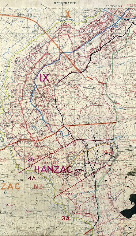
English: Wytschaete Edition 5A |
|||||||||||||||||||||||
| Description |
English: 1:20000 scale attack planning map from the Battle of Messines. The objectives are II ANZAC, IX and X Corps are marked. The II ANZAC sector has greater detail. |
|||||||||||||||||||||||
| Date | ||||||||||||||||||||||||
| Source | http://www.awm.gov.au/blog/wp-content/uploads/maps/Messines.pdf | |||||||||||||||||||||||
| Creator |
Field Service Battalion, Royal Engineers |
|||||||||||||||||||||||
| Permission (Reusing this file) |
|
|||||||||||||||||||||||
| Geotemporal data | ||||||||||||||||||||||||
| Date depicted | ||||||||||||||||||||||||
| Map location | Wytschaete | |||||||||||||||||||||||
| Map type | trench map | |||||||||||||||||||||||
| Scale | 1:20,000 | |||||||||||||||||||||||
| Bounding box |
|
|||||||||||||||||||||||
| Georeferencing | ||||||||||||||||||||||||
| Bibliographic data | ||||||||||||||||||||||||
| Map sheet | 13:18:1 | |||||||||||||||||||||||
| Language | English | |||||||||||||||||||||||
| Publisher |
Royal Engineers |
|||||||||||||||||||||||
| Archival data | ||||||||||||||||||||||||
| Collection |
|
|||||||||||||||||||||||
| Other versions | ||||||||||||||||||||||||


.jpg)
File history
Click on a date/time to view the file as it appeared at that time.
| Date/Time | Thumbnail | Dimensions | User | Comment | |
|---|---|---|---|---|---|
| current | 01:38, 5 June 2018 | | 2,598 × 4,496 (8.09 MB) | Labattblueboy | auto tone |
| 21:37, 30 October 2009 |  | 2,598 × 4,496 (7.67 MB) | Labattblueboy | {{Information |Description=1:20000 scale attack planning map from the Battle of Messines. The objectives are II ANZAC, IX and X Corps are marked. The II ANZAC sector has greater detail. |Source=Exerpt from Australian War Memorial (www.awm.gov.au) |Date= |
File usage
The following pages on the English Wikipedia use this file (pages on other projects are not listed):
Global file usage
The following other wikis use this file:
- Usage on fr.wikipedia.org
- Usage on uk.wikipedia.org
- Usage on www.wikidata.org
.jpg)