
File:Arcole campaign first phase.svg

Original file (SVG file, nominally 1,156 × 1,044 pixels, file size: 506 KB)
| This is a file from the Wikimedia Commons. Information from its description page there is shown below. Commons is a freely licensed media file repository. You can help. |
Summary
| Description |
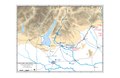
English: Map shows the first phase of the Arcole campaign, after the battles of San Michele, 2nd Bassano, and Calliano
|
||||||||||||||||||||||||
| Date | |||||||||||||||||||||||||
| Source |
Own work based on: Information from: |
||||||||||||||||||||||||
| Author | Goran_tek-en | ||||||||||||||||||||||||
| Permission (Reusing this file) |
This file is licensed under the Creative Commons Attribution-Share Alike 4.0 International license. Attribution: Goran tek-en
|
||||||||||||||||||||||||
| Other versions |
|
||||||||||||||||||||||||
| SVG development | This vector image was created with Inkscape. |
||||||||||||||||||||||||


| Object location | | View this and other nearby images on: OpenStreetMap |
|---|


File history
Click on a date/time to view the file as it appeared at that time.
| Date/Time | Thumbnail | Dimensions | User | Comment | |
|---|---|---|---|---|---|
| current | 11:34, 20 November 2021 | | 1,156 × 1,044 (506 KB) | Goran tek-en | {{Information |description ={{en|Map shows the first phase of the Arcole campaign, after the battles of San Michele, 2nd Bassano, and Calliano}} {{Institution |wikidata=Q18817}} {{Institution |wikidata=Q7818}} |date =2021-11-20 |source ={{Own}}<br> {{Derived from|Nap07.pdf|Siege of Mantua Campaign Map 1796 1797.JPG|Arcole 1796 Campaign Map.jpg|Maps template-en.svg|Template of Military Symbols.svg|BlankMap-World gray.svg}} Derived from; *[https://www.openstreetmap.org... |
File usage
Global file usage
The following other wikis use this file:
- Usage on it.wikipedia.org
- Usage on ka.wikipedia.org