
File:AMH-5603-NA Map of Algoa Bay.jpg

Size of this preview: 772 × 600 pixels. Other resolutions: 309 × 240 pixels | 618 × 480 pixels | 989 × 768 pixels | 1,280 × 994 pixels | 2,400 × 1,864 pixels.
Original file (2,400 × 1,864 pixels, file size: 845 KB, MIME type: image/jpeg)
| This is a file from the Wikimedia Commons. Information from its description page there is shown below. Commons is a freely licensed media file repository. You can help. |
Summary
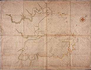
Nederlands: Kaart van de Algoa baai
English: Map of Algoa Bay( |
||||||||||||||||||||||||
|---|---|---|---|---|---|---|---|---|---|---|---|---|---|---|---|---|---|---|---|---|---|---|---|---|
| Author |
Nederlands: Cornelis Heeremans (landmeter / kaartenmaker), Wilhelm (Jansz.) Blaeu (drukker)
English: Cornelis Heeremans (land surveyor / mapmaker), Wilhelm (Jansz.) Blaeu (printer) |
|||||||||||||||||||||||
| Title |
Nederlands: Kaart van de Algoa baai
English: Map of Algoa Bay |
|||||||||||||||||||||||
| Description |
Nederlands: Titel catalogus Leupe (NA): Kaart van de Delagaobaai.
Kompaslijnen gedrukt bij Willem Blaeu (dit gedrukte papier werd ook na diens sterven in 1638 nog dikwijls gebruikt). Notities verso: De Delagoa baai van Afrika [in potlood] / 23 [in potlood] / No. 2.English: Title in the Leupe catalogue (NA): Kaart van de Delagaobaai.
Compass lines printed by Willem Blaeu (this printed paper was used often afther his death in 1638). Notes on reverse: De Delagoa baai van Afrika [in pencil] / 23 [in pencil] / No. 2. |
|||||||||||||||||||||||
| Date | circa 1680 | |||||||||||||||||||||||
| Medium |
Nederlands: ingekleurde tekening op papier
English: coloured drawing on paper |
|||||||||||||||||||||||
| Dimensions | height: 104 cm (40.9 in); width: 80 cm (31.4 in) | |||||||||||||||||||||||
| Collection |
|
|||||||||||||||||||||||
| Accession number |
NL-HaNA_4.VELH_103 (old number: VELH0103) |
|||||||||||||||||||||||
| Inscriptions |
-
author: Gedruckt by Wilhelm Blaeu / Cornelis Heeremans |
|||||||||||||||||||||||
| Notes |
English: Subjects: chart / map / plan, compass / dial
Nederlands: Onderwerpen: plattegrond / kaart, kompas / windroos
English: Post: this image is related to a VOC trading post called Maputo |
|||||||||||||||||||||||
| Source/Photographer |
|
|||||||||||||||||||||||
| Permission (Reusing this file) |
|
|||||||||||||||||||||||


| Object location | | View this and other nearby images on: OpenStreetMap |
|---|
File history
Click on a date/time to view the file as it appeared at that time.
| Date/Time | Thumbnail | Dimensions | User | Comment | |
|---|---|---|---|---|---|
| current | 08:41, 11 June 2014 | | 2,400 × 1,864 (845 KB) | HuskyBot | == {{int:filedesc}} == {{Artwork |title = {{nl|1=Kaart van de Algoa baai}} {{en|1=Map of Algoa Bay}} |description = {{nl|1=Titel catalogus Leupe (NA): ''Kaart van de Delagaobaai''. Kompaslijnen gedrukt bij Wil... |
File usage
The following pages on the English Wikipedia use this file (pages on other projects are not listed):
Global file usage
The following other wikis use this file:
- Usage on af.wikipedia.org
- Usage on de.wikipedia.org
- Usage on el.wikipedia.org