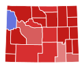
File:2020 United States Senate election in Wyoming results map by county.svg

Size of this PNG preview of this SVG file: 778 × 599 pixels. Other resolutions: 312 × 240 pixels | 623 × 480 pixels | 997 × 768 pixels | 1,280 × 986 pixels | 2,560 × 1,972 pixels | 810 × 624 pixels.
Original file (SVG file, nominally 810 × 624 pixels, file size: 15 KB)
File history
Click on a date/time to view the file as it appeared at that time.
| Date/Time | Thumbnail | Dimensions | User | Comment | |
|---|---|---|---|---|---|
| current | 05:28, 7 October 2023 |  | 810 × 624 (15 KB) | Putitonamap98 | shapes |
| 11:53, 13 December 2022 |  | 744 × 578 (86 KB) | Putitonamap98 | Reverted to version as of 15:40, 15 May 2021 (UTC) fix | |
| 11:52, 13 December 2022 |  | 744 × 578 (87 KB) | Putitonamap98 | shapes | |
| 09:51, 22 July 2021 |  | 221 × 183 (22 KB) | Putitonamap98 | Reverted to version as of 04:11, 15 May 2021 (UTC) Goshen county is incorrect | |
| 15:40, 15 May 2021 |  | 744 × 578 (86 KB) | WikiBunny2K1 | Reverted to version as of 01:36, 15 May 2021 (UTC) | |
| 04:11, 15 May 2021 |  | 221 × 183 (22 KB) | TylerKutschbach | Reverted to version as of 19:29, 17 November 2020 (UTC) | |
| 01:36, 15 May 2021 |  | 744 × 578 (86 KB) | WikiBunny2K1 | New shapes | |
| 19:29, 17 November 2020 |  | 221 × 183 (22 KB) | Zyxoriv | Reverted to version as of 19:27, 17 November 2020 (UTC) | |
| 19:28, 17 November 2020 |  | 221 × 183 (22 KB) | Zyxoriv | Reverted to version as of 16:11, 14 November 2020 (UTC) | |
| 19:27, 17 November 2020 |  | 221 × 183 (22 KB) | Zyxoriv | Updated according to 17/11/2020 New York Times results |
File usage
The following pages on the English Wikipedia use this file (pages on other projects are not listed):
Global file usage
The following other wikis use this file:
- Usage on es.wikipedia.org
- Usage on simple.wikipedia.org
