
File:20191123 Guyana 0197 Fort Island sRGB.jpg

Original file (5,472 × 3,648 pixels, file size: 7.98 MB, MIME type: image/jpeg)
| This is a file from the Wikimedia Commons. Information from its description page there is shown below. Commons is a freely licensed media file repository. You can help. |
Summary
| Description |
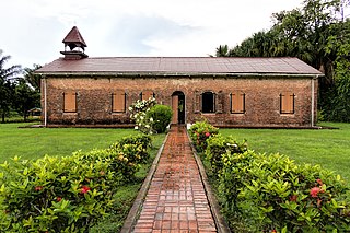
English: The Court of Policy Hall was built around 1752 after the fort was completed. The brick walls are 24 inches thick. Inside are three chambers: a large central hall flanked by smaller rooms. The central hall was used as a church and contains three tombs. The Courts of Justice and Policy met in the room on the north [right] end. The Consistory (council meeting place) on the south end was also used an office for the auctioning of African slaves. In 2007 an extensive renovation was completed and the Hall reopened as the Dutch Heritage Museum.
Fort Island in the Essequibo River delta was originally called Flag Island due to a large flag that was a guide to ships. In 1740 the Dutch commenced building a small brick fort with African slave labor to replace a rotting wooden redoubt from 1726. The fort was named Fort Zeelandia as many of the area’s original settlers had come from the County of Zeeland in the Netherlands. Flag Island was renamed Fort Island in 1775. Although initially a very substantial defense, by 1781 the fort had deteriorated and was captured by the British, taken over by the French the next year, and then back in Dutch hands two years later. The fort had entered into a long period of decline by 1796. Guyana means “land of many waters” in an indigenous Amerindian language and was the original name for an entire region covering northern South America between the Orinoco (in Venezuela) and Amazon (in Brazil) Rivers. Christopher Columbus saw Guyana on his third voyage in 1498 and Sir Walter Raleigh published a fanciful description in 1595, but the first European colony was not established until 1616 with the arrival of the Dutch. They created two more colonies (in 1627 and 1752) before the British gained control in 1796 (when fighting the French who occupied the Netherlands) with the Dutch formally ceding the area in 1814. It officially became British Guiana in 1831. The economy was driven by sugar plantations worked by African slaves—more than 100,000 by 1830. Upon emancipation in 1838, agricultural production plummeted. Replacement workers were eventually found in India, with 240,000 indentured servants having been brought over by the time indentured labor was abolished in 1917. Bauxite mining beginning in 1914 created an industry that equals sugar (and rice) today (but gold is by far the leading export). Independence from the United Kingdom was achieved in 1966 with Guyana becoming an official republic within the British Commonwealth of Nations in 1970. Guyana is the only country in South America where English is the official language (but the majority of the population speaks Guyanese Creole, a version of Creole with a basis in English). On Google Earth: Fort Island 6°47'32.83"N, 58°30'28.80"W |
| Date | Taken on 23 November 2019, 10:09:32 |
| Source | https://www.flickr.com/photos/9508280@N07/49295923167/ |
| Author | Dan Lundberg |
| Camera location | | View this and other nearby images on: OpenStreetMap |
|---|
Licensing
- You are free:
- to share – to copy, distribute and transmit the work
- to remix – to adapt the work
- Under the following conditions:
- attribution – You must give appropriate credit, provide a link to the license, and indicate if changes were made. You may do so in any reasonable manner, but not in any way that suggests the licensor endorses you or your use.
- share alike – If you remix, transform, or build upon the material, you must distribute your contributions under the same or compatible license as the original.
| This image was originally posted to Flickr by Dan Lundberg at https://flickr.com/photos/9508280@N07/49295923167. It was reviewed on 28 July 2020 by FlickreviewR 2 and was confirmed to be licensed under the terms of the cc-by-sa-2.0. |
File history
Click on a date/time to view the file as it appeared at that time.
| Date/Time | Thumbnail | Dimensions | User | Comment | |
|---|---|---|---|---|---|
| current | 14:17, 28 July 2020 | | 5,472 × 3,648 (7.98 MB) | Fentener van Vlissingen | Uploaded a work by Dan Lundberg from https://www.flickr.com/photos/9508280@N07/49295923167/ with UploadWizard |
File usage
Global file usage
The following other wikis use this file:
- Usage on nl.wikipedia.org
- Usage on pap.wikipedia.org
- Usage on www.wikidata.org