
File:1908* Edgartown Light area USGS Topo Map.png

Size of this preview: 739 × 599 pixels. Other resolutions: 296 × 240 pixels | 592 × 480 pixels | 947 × 768 pixels | 1,174 × 952 pixels.
Original file (1,174 × 952 pixels, file size: 1.85 MB, MIME type: image/png)
| This is a file from the Wikimedia Commons. Information from its description page there is shown below. Commons is a freely licensed media file repository. You can help. |
Summary
| Description |
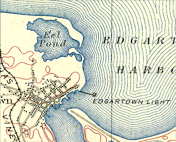
English: 1908 United States Geological Service (USGS) topographic map depicting the Edgartown Light and surrounding vicinity. The map clearly illustrates Edgartown Light as being surrounded by water and connected to a point of land via the stone causeway first constructed in 1847.
Located to the northeast of Edgartown Light is Eel Pond as it existed in 1908 with its massive barrier beach. A series of hurricanes in the 1950s destroyed the Eel Pond barrier beach. The destabilized Eel Pond sands were carried by the prevailing southeasterly littoral drift toward Edgartown Light. Due to oceanic current and tidal influences, a large volume of these sands were deposited in the location surrounding the Edgartown Light. This configuration of beach surrounding the Edgartown Light continues to exist today, even though it has slowly experienced erosion since the 1950s.
Also shown in this USGS topo map is the sparsely populated Town of Edgartown with a railroad track system crossing the town's west side. This railway was created by developers to transport prospective buyers from the Oak Bluffs steamship ferry terminal to view subdivided lots-for-sale located near South Beach in Katama. |
| Date | |
| Source | United States Geological Service |
| Author | William Waterway |
Licensing
This work is in the public domain in the United States because it was published (or registered with the U.S. Copyright Office) before January 1, 1929.
Public domain works must be out of copyright in both the United States and in the source country of the work in order to be hosted on the Commons. If the work is not a U.S. work, the file must have an additional copyright tag indicating the copyright status in the source country.
Note: This tag should not be used for sound recordings. |
This image is in the public domain in the United States because it only contains materials that originally came from the United States Geological Survey, an agency of the United States Department of the Interior. For more information, see the official USGS copyright policy.
|
File history
Click on a date/time to view the file as it appeared at that time.
| Date/Time | Thumbnail | Dimensions | User | Comment | |
|---|---|---|---|---|---|
| current | 17:14, 28 October 2012 | | 1,174 × 952 (1.85 MB) | Williamwaterway | User created page with UploadWizard |
File usage
The following pages on the English Wikipedia use this file (pages on other projects are not listed):