
Fairview Heights station (MetroLink)
Fairview Heights | ||||||||||||||||
|---|---|---|---|---|---|---|---|---|---|---|---|---|---|---|---|---|
| General information | ||||||||||||||||
| Location | 9720 West Illinois Route 161 Fairview Heights, Illinois | |||||||||||||||
| Coordinates | 38°35′37″N 90°02′52″W / 38.593617°N 90.047835°W | |||||||||||||||
| Owned by | Bi-State Development | |||||||||||||||
| Operated by | Metro Transit | |||||||||||||||
| Platforms | 1 island platform | |||||||||||||||
| Tracks | 2 | |||||||||||||||
| Bus stands | 7[1] | |||||||||||||||
| Connections | ||||||||||||||||
| Construction | ||||||||||||||||
| Structure type | At-grade | |||||||||||||||
| Parking | 898 spaces[3] | |||||||||||||||
| Bicycle facilities | Racks, MetroBikeLink Trail | |||||||||||||||
| Accessible | Yes | |||||||||||||||
| History | ||||||||||||||||
| Opened | May 5, 2001[4] | |||||||||||||||
| Passengers | ||||||||||||||||
| 2018 | 1,611 daily | |||||||||||||||
| Rank | 7 out of 38 | |||||||||||||||
| Services | ||||||||||||||||
| ||||||||||||||||
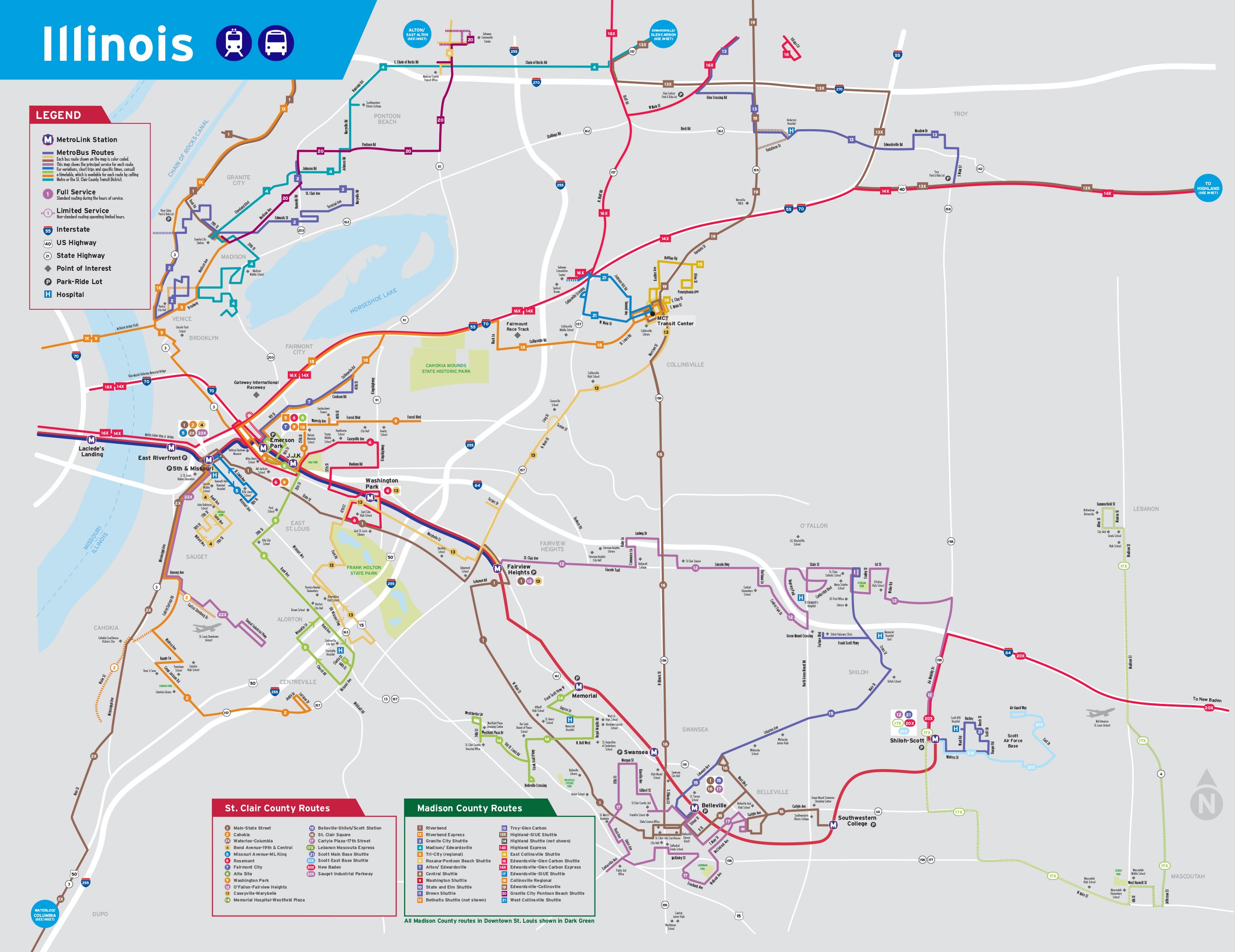
Fairview Heights station is a light rail station on the Red and Blue lines of the St. Louis MetroLink system.[5] This at-grade station is located on the western edge of Fairview Heights, Illinois near the intersection of St. Clair Avenue and Illinois Route 161. It is the eastern terminus of the Blue Line and has a pocket track allowing Blue Line trains to reverse directions and layover between runs.
Fairview Heights is primarily a commuter station with 898 park and ride spaces and a large MetroBus transfer.
Station layout[edit]
The island platform is accessed via a single ramp on its west end that connects to the bus boarding area and park and ride lot.
| Street | Entrance/exit, bus bays, park and ride |
| Westbound | ← Blue Line toward Shrewsbury (Washington Park) ← Red Line toward Lambert Airport (Washington Park) |
| Island platform, doors will open on the left | |
| Eastbound | Red Line toward Shiloh–Scott (Memorial Hospital) → Blue Line terminating trains → |
MetroBikeLink[edit]
Fairview Heights is the northernmost station served by the St. Clair County Transit District's MetroBikeLink shared-use path system. This 3.5-mile (5.6 km) section opened in 2019 and follows former CSX right-of-way and Schoenberger Creek through the hills of the Dutch Hollow area of Belleville and Fairview Heights. This section of trail connects to the other 11.5 miles (18.5 km) of MetroBikeLink for a total of 14 miles (23 km) of paved trails along MetroLink in St. Clair County, Illinois.[6]
References[edit]
- ^ "Bus Bays" (PDF). Metro Transit. January 2021. p. 13. Retrieved May 23, 2023.
- ^ "Illinois System Map" (Map). Metro Transit. April 2019. Retrieved May 23, 2023.
- ^ "System Addresses". Metro Transit. Retrieved May 23, 2023.
- ^ Leiser, Ken (April 30, 2001). "MetroLink Extension Opens This Weekend With Parking to Spare". The St. Louis Post-Dispatch. p. A9. Retrieved April 15, 2021 – via Newspapers.com.

- ^ "Fairview Heights Station". metrostlouis.org. Retrieved 2022-10-15.
- ^ "SCCTD MetroBikeLink System". St. Clair County Transit District. Retrieved 2022-10-15.