
Elst, Belgium
Elst | |
|---|---|
Village | |
 Saint Apollonia Church of Elst (2004) | |
 Elst Location in Belgium | |
| Coordinates: 50°49′48″N 3°44′20″E / 50.830°N 3.739°E | |
| Country | |
| Region | Flemish Region |
| Province | East Flanders |
| Municipality | Brakel |
| Area | |
| • Total | 5.16 km2 (1.99 sq mi) |
| Population (2021)[1] | |
| • Total | 1,143 |
| • Density | 220/km2 (570/sq mi) |
| Time zone | CET |
Elst is a village belonging to the municipality of Brakel. It is located in the Denderstreek in the province East Flanders in Belgium.
Overview[edit]
The village was mentioned in 977 as Elsuth. There are two mills in the village.[2] The oldest is the Perlinckmolen, an overshot watermill, which originated from before 898, and is one of the oldest in Belgium. The current mill was reconstructed in 1571. In 1859, it was severely damaged in a storm. In 1974, it stopped operations, and was declared a monument the next year.[3]
The Leberg is located in the village. It is a steep 99 metre hill, and has become known as a significant obstacle in the Tour of Flanders.[4]
Elst is known for its Geutelingen, a kind of pancake.[5]
Gallery[edit]
-
 View on Elst
 -
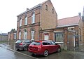 Former boys school
 -
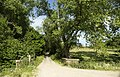 Landscape around Elst
 -
 School in Elst


References[edit]
- ^ a b "Bevolking per statistische sector - Sector 45059D". Statistics Belgium. Retrieved 4 May 2022.
- ^ "Elst". Agentschap Onroerend Erfgoed (in Dutch). Retrieved 21 October 2020.
- ^ "Perlinckmolen". Molen Echos (in Dutch). Retrieved 21 October 2020.
- ^ "De Leberg (uit de Ronde van Vlaanderen)". Zegelsem (in Dutch). Retrieved 21 October 2020.
- ^ "Geutelingen". Retrieved 2010-03-21.
External links[edit]
 Media related to Elst, Belgium at Wikimedia Commons
- Toerisme Brakel - Local tourist service
Belgian municipality Brakel | |
|---|---|
| Deelgemeentes | |
| Other settlements | |
| Buildings and structures | |
This East Flanders location article is a stub. You can help Wikipedia by expanding it. |