
El Yunque (Cuba)
| El Yunque | |
|---|---|
 | |
| Highest point | |
| Elevation | 575 m (1,886 ft)[1] |
| Coordinates | 20°21′08″N 74°34′26″W / 20.35222°N 74.57389°W |
| Naming | |
| English translation | The anvil |
| Language of name | (in Spanish) |
| Geography | |
| Location | Cuba |
| Parent range | Sierra del Purial (Nipe-Sagua-Baracoa) |
| Geology | |
| Mountain type | Table mountain |
El Yunque is a 575-metre-high (1,886 ft) mountain located 7 km (4.3 mi) west of Baracoa and the Baracoa Bay in Cuba's Guantanamo Province. It has a table mountain shape that resembles an anvil ("yunque" in Spanish).
Overview[edit]
El Yunque was mentioned by Christopher Columbus in his chronicles about the discovery of the Americas.[2] The Yunque is situated between the banks of the rivers Duaba and Toa, it is 1,125 m (3,691 ft) long and has a total area of 461,000 m2 (4,960,000 sq ft).
El Yunque was declared a National Monument by the Cuban National Commission of Monuments on December 25, 1979.[1] El Yunque is covered with Cuban moist forests and the lower slopes are planted with cocoa bean under the shade of groves of royal palm.
Gallery[edit]
-
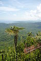 View from El Yunque
 -
 El Yunque from Baracoa bay
 -
 El Yunque in 2006
 -
 View to the west from the foot of El Yunque


References[edit]
- ^ a b Baracoa.org. "El Yunque". Archived from the original on 2007-06-11. Retrieved 2006-09-29.
- ^ Columbus Monuments Pages. "Baracoa". Retrieved 2007-09-29.
External links[edit]
![]() Media related to El Yunque at Wikimedia Commons
Media related to El Yunque at Wikimedia Commons
This Cuban location article is a stub. You can help Wikipedia by expanding it. |