
Canton of Picquigny
49°56′42″N 2°8′41″E / 49.94500°N 2.14472°E
Picquigny | |
|---|---|
Former canton | |
| Country | France |
| Region | Hauts-de-France |
| Department | Somme |
| No. of communes | 21 |
| Disbanded | 2015 |
| Seat | Picquigny |
| Area | 208.05 km2 (80.33 sq mi) |
| Population (2012) | 18,451 |
| • Density | 89/km2 (230/sq mi) |
The Canton of Picquigny is a former canton situated in the department of the Somme and in the Picardy region of northern France. It was disbanded following the French canton reorganisation which came into effect in March 2015. It had 18,451 inhabitants (2012).[1]
Geography[edit]
The canton is organised around the commune of Picquigny in the arrondissement of Amiens. The altitude varies from 6m at Flixecourt to 134m at Vignacourt for an average of 50m.
The canton comprised 21 communes:[1]
Places of interest[edit]
-
 The château at Picquigny
 -
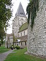 The church
.JPG)

Population[edit]
| 1962 | 1968 | 1975 | 1982 | 1990 | 1999 |
|---|---|---|---|---|---|
| 15038 | 16084 | 18248 | 18336 | 17735 | 17702 |
| Census count starting from 1962 : Population without double counting | |||||
See also[edit]
- Arrondissements of the Somme department
- Cantons of the Somme department
- Communes of the Somme department
References[edit]
This Somme geographical article is a stub. You can help Wikipedia by expanding it. |