Ardagh, County Mayo
Ardagh | |
|---|---|
Civil parish | |
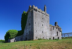
 Deel Castle is a fortified tower house beside the River Deel in the civil parish of Ardagh | |
| Coordinates: 54°05′52″N 9°13′32″W / 54.09778°N 9.22556°W | |
| Country | Ireland |
| County | Mayo |
Ardagh (Irish: Ardach)[1] is a civil parish and townland in County Mayo, located slightly to the southwest of Ballina.[2][3][4]
The parish takes its name from an ancient ecclesiastical site, which was either a church or a small monastery, and is derived from "Ard Achadh", which means high ground.[2] The earliest record of the first church in Ardagh is in an 1198 epistle issued by Pope Innocent 3rd.[5] The parish contains two castles: Deel Castle and Rappa Castle. There is also a community centre, a Gaelic football pitch, three national schools, and a local pub, Mickey O'Boyles (The Halfway House).[citation needed]
References[edit]
- ^ "Ardach / Ardagh". logainm.ie. Placenames Database of Ireland. Retrieved 15 January 2021.
- ^ a b Crossmolina Historical & Archaeological Society. "The Deel Basin – an Historical Survey 1990". Retrieved 18 November 2021 – via mayo-ireland.ie.
- ^ Lewis Topographical Dictionary of Ireland 1837 Archived 4 July 2008 at the Wayback Machine
- ^ "ARDAGH MAYO IRELAND Geography Population Map cities coordinates location". Tageo.com. Retrieved 16 April 2013.
- ^ "Antiquities", Irish Tourist Association Survey, 1942 Archived 3 March 2016 at the Wayback Machine
