
Portal:Myanmar
ကြိုဆိုပါတယ်။ / Welcome to the Myanmar Portal 

Myanmar, officially the Republic of the Union of Myanmar and also known as Burma (the official name until 1989), is a country in Southeast Asia. It is the largest country by area in Mainland Southeast Asia and has a population of about 55 million. It is bordered by Bangladesh and India to its northwest, China to its northeast, Laos and Thailand to its east and southeast, and the Andaman Sea and the Bay of Bengal to its south and southwest. The country's capital city is Naypyidaw, and its largest city is Yangon (formerly Rangoon).
Myanmar is a member of the East Asia Summit, Non-Aligned Movement, ASEAN, and BIMSTEC, but it is not a member of the Commonwealth of Nations despite once being part of the British Empire. Myanmar is a Dialogue Partner of the Shanghai Cooperation Organization. The country is very rich in natural resources, such as jade, gems, oil, natural gas, teak and other minerals, as well as also endowed with renewable energy, having the highest solar power potential compared to other countries of the Great Mekong Subregion. However, Myanmar has long suffered from instability, factional violence, corruption, poor infrastructure, as well as a long history of colonial exploitation with little regard to human development. In 2013, its GDP (nominal) stood at US$56.7 billion and its GDP (PPP) at US$221.5 billion. The income gap in Myanmar is among the widest in the world, as a large proportion of the economy is controlled by cronies of the military junta. Myanmar is one of the least developed countries; as of 2020, according to the Human Development Index, it ranks 147 out of 189 countries in terms of human development, the lowest in Southeast Asia. Since 2021, more than 600,000 people were displaced across Myanmar due to the surge in violence post-coup, with more than 3 million people in dire need of humanitarian assistance. (Full article...)
Selected articles -
-
![Image 1 The National League for Democracy (Burmese: အမျိုးသား ဒီမိုကရေစီ အဖွဲ့ချုပ်, IPA: [ʔəmjóðá dìmòkəɹèsì ʔəpʰwḛdʑoʊʔ]; abbr. NLD; Burmese abbr. ဒီချုပ်) is a deregistered liberal democratic political party in Myanmar (Burma). It became the country's ruling party after a landslide victory in the 2015 general election but was overthrown in a military coup d'état in February 2021 following another landslide election victory in 2020. Founded on 27 September 1988, the NLD has become one of the most influential parties in Myanmar's pro-democracy movement. Aung San Suu Kyi, the former State Counsellor of Myanmar, serves as its leader. The party won a substantial parliamentary majority in the 1990 Myanmar general election. However, the ruling military junta refused to recognise the result. On 6 May 2010, the party was declared illegal and ordered to be disbanded by the junta after refusing to register for the elections slated for November 2010. In November 2011, the NLD announced its intention to register as a political party to contest future elections, and Myanmar's Union Election Commission approved their application for registration on 13 December 2011. (Full article...)](//upload.wikimedia.org/wikipedia/en/d/d2/Blank.png) The National League for Democracy (Burmese: အမျိုးသား ဒီမိုကရေစီ အဖွဲ့ချုပ်, IPA: [ʔəmjóðá dìmòkəɹèsì ʔəpʰwḛdʑoʊʔ]; abbr. NLD; Burmese abbr. ဒီချုပ်) is a deregistered liberal democratic political party in Myanmar (Burma). It became the country's ruling party after a landslide victory in the 2015 general election but was overthrown in a military coup d'état in February 2021 following another landslide election victory in 2020.
The National League for Democracy (Burmese: အမျိုးသား ဒီမိုကရေစီ အဖွဲ့ချုပ်, IPA: [ʔəmjóðá dìmòkəɹèsì ʔəpʰwḛdʑoʊʔ]; abbr. NLD; Burmese abbr. ဒီချုပ်) is a deregistered liberal democratic political party in Myanmar (Burma). It became the country's ruling party after a landslide victory in the 2015 general election but was overthrown in a military coup d'état in February 2021 following another landslide election victory in 2020.
Founded on 27 September 1988, the NLD has become one of the most influential parties in Myanmar's pro-democracy movement. Aung San Suu Kyi, the former State Counsellor of Myanmar, serves as its leader. The party won a substantial parliamentary majority in the 1990 Myanmar general election. However, the ruling military junta refused to recognise the result. On 6 May 2010, the party was declared illegal and ordered to be disbanded by the junta after refusing to register for the elections slated for November 2010. In November 2011, the NLD announced its intention to register as a political party to contest future elections, and Myanmar's Union Election Commission approved their application for registration on 13 December 2011. (Full article...) -
There is a history of persecution of Muslims in Myanmar that continues to the present day. Myanmar is a Buddhist majority country, with significant Christian and Muslim minorities. While Muslims served in the government of Prime Minister U Nu (1948–63), the situation changed with the 1962 Burmese coup d'état. While a few continued to serve, most Christians and Muslims were excluded from positions in the government and army. In 1982, the government introduced regulations that denied citizenship to anyone who could not prove Burmese ancestry from before 1823. This disenfranchised many Muslims in Myanmar, even though they had lived in Myanmar for several generations.
The Rohingya people are a large Muslim group in Myanmar; the Rohingyas have been among the most persecuted group under Myanmar's military regime, with the Kachin, who are predominantly U.S. Baptists, a close second. The UN states that the Rohingyas are one of the most persecuted groups in the world. Since 1948, successive governments have carried out 13 military operations against the Rohingya (including in 1975, 1978, 1989, 1991–92, 2002). During the operations, Myanmar security forces have driven the Rohingyas off their land, burned down their mosques and committed widespread looting, arson and rape of Rohingya Muslims. Outside of these military raids, Rohingya are subjected to frequent theft and extortion from the authorities and many are subjected to forced labor. In some cases, land occupied by Rohingya Muslims has been confiscated and reallocated to local Buddhists. (Full article...) -

The British colonial rule in Burma lasted from 1824 to 1948, from the successive three Anglo-Burmese wars through the creation of Burma as a province of British India to the establishment of an independently administered colony, and finally independence. The region under British control was known as British Burma, and officially known as Burma (Burmese: မြန်မာနိုင်ငံတော်) from 1886. Various portions of Burmese territories, including Arakan and Tenasserim, were annexed by the British after their victory in the First Anglo-Burmese War; Lower Burma was annexed in 1852 after the Second Anglo-Burmese War. The annexed territories were designated the minor province (a chief commissionership) of British Burma in 1862.
After the Third Anglo-Burmese War in 1885, Upper Burma was annexed, and the following year, the province of Burma in British India was created, becoming a major province (a lieutenant-governorship) in 1897. This arrangement lasted until 1937, when Burma began to be administered separately by the Burma Office under the Secretary of State for India and Burma. British rule was disrupted during the Japanese occupation of much of the country during World War II. Burma achieved independence from British rule on 4 January 1948. (Full article...) -
Myanmar (also written as Makha Bucha Day) is a Buddhist festival celebrated on the full moon day of the third lunar month in Cambodia, Laos, Thailand, Sri Lanka and on the full moon day of Tabaung in Myanmar. It is the second most important Buddhist festival after Vesak; it celebrates a gathering that was held between the Buddha and 1,250 of his first disciples, which, according to tradition, preceded the custom of periodic recitation of discipline by monks. On the day, Buddhists celebrate the creation of an ideal and exemplary community, which is why it is sometimes called Saṅgha Day, the Saṅgha referring to the Buddhist community, and for some Buddhist schools this is specifically the monastic community. In Thailand, the Pāli term Māgha-pūraṇamī is also used for the celebration, meaning 'to honor on the full moon of the third lunar month'. Finally, some authors referred to the day as the Buddhist All Saints Day.
In pre-modern times, Māgha Pūjā has been celebrated by some Southeast Asian communities. But it became widely popular in the modern period, when it was instituted in Thailand by King Rama IV in the mid-19th century. From Thailand, it spread to other South and Southeast Asian countries. Presently, it is a public holiday in some of these countries. It is an occasion when Buddhists go to the temple to perform merit-making activities, such as alms giving, meditation and listening to teachings. It has been proposed in Thailand as a more spiritual alternative to the celebration of Valentine's Day. (Full article...) -
Hkakabo Razi (Burmese: ခါကာဘိုရာဇီ, pronounced [kʰàkàbò ɹàzì]; simplified Chinese: 开加博峰; traditional Chinese: 開加博峯; pinyin: Kāijiābó Fēng) is believed to be Myanmar's highest mountain. The 5,881-meter (19,295 ft)-tall mountain is the highest mountain in Southeast Asia as well. It is located in the northern Myanmar state of Kachin in an outlying subrange of the Greater Himalayan mountain system near the border tripoint with India and China. Its highest status has recently been challenged by 5,870-meter (19,260 ft)-tall Gamlang Razi, located about 6.6 kilometers (4.1 mi) WSW on the Chinese border.
The peak is enclosed within Khakaborazi National Park. The park is entirely mountainous and is characterized by broad-leaved evergreen tropical rain forest at low altitudes, a sub-tropical temperate zone from 8,000 to 9,000 ft (2,400–2,700 m), then broad-leaved, semi-deciduous forest and finally needle-leaved evergreen, snow forest. Above 11,000 ft (3,400 m), the highest forest zone is alpine, different from the forest not only in kind but in history and origin. Still higher, around 15,000 ft (4,600 m), cold, barren, windswept terrain and permanent snow and glaciers dominate. At around 17,500 ft (5,300 m), there is a large ice cap with several outlet glaciers. (Full article...) -

U Thaw (Burmese: ဦးသော်; 5 September 1893 – 25 June 1980), known honorifically as Baganset U Thaw (Burmese: ပန်းကန်စက် ဦးသော်), was a Burmese businessman, trader, administrator, and politician. He was the first manufacturer of porcelain products in Burma. He was a member of the Legislative Council of Burma, patron of the Young Men's Buddhist Association (YMBA), chairman of Myoma National High School Administration Board, and one of the leaders of the General Council of Burmese Associations. (Full article...) -
Hkakaborazi National Park is a national park in northern Myanmar with an area of 1,472 sq mi (3,810 km2). It was established in 1998.
It surrounds Hkakabo Razi, the highest mountain in the country.
It ranges in elevation from 2,950 to 18,730 ft (900 to 5,710 m) comprising evergreen forest and mixed deciduous forests in Nogmung Township, Kachin State. It is managed by the Nature and Wildlife Conservation Division.
It is contiguous with Bumhpa Bum Wildlife Sanctuary and Hukaung Valley Wildlife Sanctuary. These protected areas together with Hponkanrazi Wildlife Sanctuary comprise the largest continuous expanse of natural forest called the Northern Forest Complex stretching over an area of 11,624 sq mi (30,110 km2). Its objective is to conserve the biodiversity of the Ayeyarwady and Chindwin river basins. (Full article...) -
Zigrasimecia is an extinct genus of ants which existed in the Cretaceous period approximately 98 million years ago. The first specimens were collected from Burmese amber in Kachin State, 100 kilometres (62 mi) west of Myitkyina town in Myanmar. In 2013, palaeoentomologists Phillip Barden and David Grimaldi published a paper describing and naming Zigrasimecia tonsora. They described a dealate female with unusual features, notably the highly specialized mandibles. Other features include large ocelli, short scapes, 12 antennomeres, small eyes, and a clypeal margin that has a row of peg-like denticles. The genus Zigrasimecia was originally incertae sedis (uncertain placement) within Formicidae until a second species, Zigrasimecia ferox, was described in 2014, leading to its placement in the subfamily Sphecomyrminae. Later, it was considered to belong to the distinct subfamily Zigrasimeciinae.
Due to the highly specialized mandibles, scientists believe that the ants exhibited habits no longer seen in extant ants. The highly movable head suggests that mobility was an important factor for them (probably for feeding behavior), and the rugose projections may have played a major role in nest excavation because the mandibles would have prevented such activity. Zigrasimecia most likely interacted with the extinct ant genus Gerontoformica through conflict and probably shared some of their ecological niches. The mandibles of these ants were probably used for mechanical interactions with food, and they may also have served as traps for potential arthropod prey such as mites and small flies. Zigrasimecia was possibly a generalist predator. (Full article...) -
The Burmese calendar (Burmese: မြန်မာသက္ကရာဇ်, pronounced [mjəmà θɛʔkəɹɪʔ], or ကောဇာသက္ကရာဇ်, [kɔ́zà θɛʔkəɹɪʔ]; Burmese Era (BE) or Myanmar Era (ME)) is a lunisolar calendar in which the months are based on lunar months and years are based on sidereal years. The calendar is largely based on an older version of the Hindu calendar, though unlike the Indian systems, it employs a version of the Metonic cycle. The calendar therefore has to reconcile the sidereal years of the Hindu calendar with the Metonic cycle's near tropical years by adding intercalary months and days at irregular intervals.
The calendar has been used continuously in various Burmese states since its purported launch in 640 CE in the Sri Ksetra Kingdom, also called the Pyu era. It was also used as the official calendar in other mainland Southeast Asian kingdoms of Arakan, Lan Na, Xishuangbanna, Lan Xang, Siam, and Cambodia down to the late 19th century. (Full article...) -
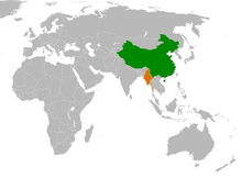
China–Myanmar relations (Chinese: 中缅关系; Burmese: တရုတ်မြန်မာဆက်ဆံရေး) are the international relations between the People's Republic of China and Myanmar. China and Myanmar have active bilateral relations with each other. The relation is often described as a pauk-phaw relationship (Burmese: ပေါက်ဖော်), based a Burmese term for kinsfolk that implicates special asymmetric obligations between the two countries.
Generally, China has maintained positive relationships with both military and elected governments in Myanmar. Bilateral relations between China and Myanmar have also faced difficulties due to alleged Chinese backing of rebels in Myanmar's territories. In recent years, the relations between China and Myanmar have faced some problems due to ongoing clashes between ethnic Chinese rebels and the Myanmar military near the China–Myanmar border. (Full article...)
![Image 1 The National League for Democracy (Burmese: အမျိုးသား ဒီမိုကရေစီ အဖွဲ့ချုပ်, IPA: [ʔəmjóðá dìmòkəɹèsì ʔəpʰwḛdʑoʊʔ]; abbr. NLD; Burmese abbr. ဒီချုပ်) is a deregistered liberal democratic political party in Myanmar (Burma). It became the country's ruling party after a landslide victory in the 2015 general election but was overthrown in a military coup d'état in February 2021 following another landslide election victory in 2020. Founded on 27 September 1988, the NLD has become one of the most influential parties in Myanmar's pro-democracy movement. Aung San Suu Kyi, the former State Counsellor of Myanmar, serves as its leader. The party won a substantial parliamentary majority in the 1990 Myanmar general election. However, the ruling military junta refused to recognise the result. On 6 May 2010, the party was declared illegal and ordered to be disbanded by the junta after refusing to register for the elections slated for November 2010. In November 2011, the NLD announced its intention to register as a political party to contest future elections, and Myanmar's Union Election Commission approved their application for registration on 13 December 2011. (Full article...)](/wiki/File:Blank.png)
.svg)


Did you know (auto-generated) -

- ... that the Myanmar Coast Guard was initially proposed as a civilian law enforcement agency before being established as a branch of the military three years later?
- ... that Molly Burman resumed releasing music three years later after finding that "Happy Things" had accrued a million streams on Spotify?
- ... that Maung O, Prince of Salin, and his sister Nanmadaw Me Nu became de facto rulers of Burma when King Bagyidaw was suffering from depression?
- ... that the Myanmar Photo Archive (example photograph shown) revealed "a side of modern Myanmar that, until very recently, remained hidden in dusty attics"?
- ... that the mission of the United Nations special envoy on Myanmar has been called a "diplomatic graveyard"?
- ... that Esther Ze Naw, who appeared on the 2021 Time 100, was one of the few people in Myanmar who protested against Aung San Suu Kyi's defence of the military at the International Court of Justice in December 2019?
- ... that clashes between the Myanmar military and local armed groups broke out in Lay Kay Kaw six years after it was established as a "town of peace" between the parties?
- ... that former Burmese actress Honey Nway Oo turned rebel and took up arms against the military junta following the 2021 Myanmar coup d'état?
Related portals and projects
General images -
-
 The paddle steamer Ramapoora (right) of the British India Steam Navigation Company on the Rangoon river having just arrived from Moulmein. 1895. Photographers: Watts and Skeen (from History of Myanmar)
 -
 Myinhkin thabin - equestrian sport (from Culture of Myanmar)
 -
 Two female musicians play the saung at a performance in Mandalay. (from Culture of Myanmar)
 -
 Pagan Kingdom during Narapatisithu's reign. Burmese chronicles also claim Kengtung and Chiang Mai. Core areas shown in darker yellow. Peripheral areas in light yellow. Pagan incorporated key ports of Lower Burma into its core administration by the 13th century. (from History of Myanmar)
 -
 Jade Mine in Hpakant (from Geography of Myanmar)
 -
 Salween river at Mae Sam Laep on the Thai-Myanmar border (from Geography of Myanmar)
 -

-
 The shores of Irrawaddy River at Nyaung-U, Bagan (from Geography of Myanmar)
 -
 Saint Mary's Cathedral in Downtown Yangon is the largest Roman Catholic cathedral in Burma. (from Culture of Myanmar)
 -
 A bull fight, 19th-century watercolour (from Culture of Myanmar)
 -
 Aerial view of a burned Rohingya village in Rakhine state, Myanmar, September 2017 (from History of Myanmar)
 -
 The restored Taungoo or Nyaungyan dynasty c. 1650 CE. (from History of Myanmar)
 -
 British soldiers remove their shoes at the entrance of Shwedagon Pagoda. To the left, a sign reads "Foot wearing is strictly prohibited" in Burmese, English, Tamil, and Urdu. (from Culture of Myanmar)
 -
 A wedding procession, with the groom and bride dressed in traditional Burmese wedding clothes, reminiscent of royal attire (from Culture of Myanmar)
 -
 Myanmar (Burma) map of Köppen climate classification (from Geography of Myanmar)
 -
 British soldiers on patrol in the ruins of the Burmese town of Bahe during the advance on Mandalay, January 1945. (from History of Myanmar)
 -
 Vegetable stall on the roadside at the Madras Lancer Lines, Mandalay, January 1886. Photographer: Hooper, Willoughby Wallace (1837–1912). (from History of Myanmar)
 -
 Boxing match, 19th-century watercolour (from Culture of Myanmar)
 -
 Sculpture of Myanmar mythical lion (from Culture of Myanmar)
 -

-
 Hlei pyaingbwè - a Burmese regatta (from Culture of Myanmar)
 -
 Political Map of Burma (Myanmar) c. 1450 CE. (from History of Myanmar)
 -
 British soldiers dismantling cannons belonging to King Thibaw's forces, Third Anglo-Burmese War, Ava, 27 November 1885. Photographer: Hooper, Willoughby Wallace (1837–1912). (from History of Myanmar)
 -
 Portuguese ruler and soldiers mounting an Elephant. Philips, Jan Caspar (draughtsman and engraver) (from History of Myanmar)
 -
 Mountains near Pindaya on the Shan Plateau (from Geography of Myanmar)
 -
 Aung San Suu Kyi addresses crowds at the NLD headquarters shortly after her release. (from History of Myanmar)
 -
 19th-century funeral cart and spire, which would form part of the procession from the home to the place of cremation (from Culture of Myanmar)
 -
 Grandfather Island, Dawei (from Geography of Myanmar)
 -

-
 Mount Popa, a dormant volcano in the Central Lowlands (from Geography of Myanmar)
 -
 Protesters in Yangon with a banner that reads non-violence: national movement in Burmese, in the background is Shwedagon Pagoda. (from History of Myanmar)
 -
 Temples at Mrauk U, was the capital of the Mrauk U Kingdom, which ruled over what is now Rakhine State. (from History of Myanmar)
 -
 A wide range of Burmese lacquerware from Bagan (from Culture of Myanmar)
 -
 A large fracture on the Mingun Pahtodawgyi caused by the 1839 Ava earthquake. (from Geography of Myanmar)
 -
 Former US President Barack Obama poses barefoot on the grounds of Shwedagon Pagoda, one of Myanmar's major Buddhist pilgrimage sites. (from Culture of Myanmar)
 -
 Recorder's Court on Sule Pagoda Road, with the Sule Pagoda at the far end, Rangoon, 1868. Photographer: J. Jackson. (from History of Myanmar)
 -
 A group of Buddhist worshipers at Shwedagon Pagoda, an important religious site for Burmese Buddhists (from Culture of Myanmar)
 -

-
 A theatrical performance of the Mon dance (from Culture of Myanmar)
 -
 Protesters in Yangon carrying signs reading "Free Daw Aung San Suu Kyi" on 8 February 2021. (from History of Myanmar)


_headquarter.jpg)


Major topics
Categories

More topics

Associated Wikimedia
The following Wikimedia Foundation sister projects provide more on this subject:
-
 Commons
Free media repository -
 Wikibooks
Free textbooks and manuals -
 Wikidata
Free knowledge base -
 Wikinews
Free-content news -
 Wikiquote
Collection of quotations -
 Wikisource
Free-content library -
 Wikiversity
Free learning tools -
 Wikivoyage
Free travel guide -
 Wiktionary
Dictionary and thesaurus


