
Rench
This article may be a rough translation from German. It may have been generated, in whole or in part, by a computer or by a translator without dual proficiency. (February 2024) |
This article includes a list of references, related reading, or external links, but its sources remain unclear because it lacks inline citations. (February 2024) |
| Rench | |
|---|---|
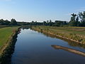
 The Rench dyke near Lautenbach | |
 Course of the Rench (interactive map) | |
| Location | |
| Country | Germany |
| State | Baden-Württemberg |
| Reference no. | DE: 2354 |
| Physical characteristics | |
| Source | |
| • location | at Kniebis near Bad Griesbach im Schwarzwald-Zuflucht source Schöngrundbächle |
| • coordinates | 48°29′27″N 8°14′49″E / 48.4908639°N 08.2469944°E |
| • elevation | ca. 915 m above sea level (NN) |
| Mouth | |
• location | at Rhine km 314.700, near Rheinau/Lichtenau/Helmlingen into the Rhine |
• coordinates | 48°43′22″N 7°58′00″E / 48.7226583°N 7.9665861°E |
• elevation | 123 m |
| Length | 57.1 km (35.5 mi) [1] |
| Basin size | 305.1 km2 (117.8 sq mi) [1] |
| Discharge | |
| • location | [2] |
| • average | 8.37 m³/s |
| Basin features | |
| Progression | Rhine→ North Sea |
| Landmarks |
|
| Population | 88650[3] |
| Tributaries | |
| • left | Ödsbach, Hesselbach |
| • right | Lierbach, Acher (Teilmenge) |
The Rench is an eastern tributary of the Rhine in the Ortenau in Central Baden, Germany. It rises on the southern edge of the Northern Black Forest at Kniebis near Bad Griesbach im Schwarzwald. The source farthest from the mouth is that of the Schöngrundbächle which rises at a height of around 915 m above NN in the parish of Zuflucht. After flowing through its steep mountainside klinge it is joined by other streams to form, first, the Old (Alter), then the Wild Rench (Wilder Rench), which first becomes the Rench below Bad Griesbach. The Rench runs in a prominent southerly arc through the Central Black Forest and crosses the hilly region of Ortenau with its orchards and vineyards before breaking out into the Rhine Plain. After just under 57 km it, together with the Mühlbach, confluences with the Rhine at 314.7 km between Helmlingen (Rheinau) and Lichtenau.
The upper Rench valley around Bad Peterstal-Griesbach initially cuts into the forested bunter sandstone plateau before entering a more open, very steep rugged valley, near the town of Oppenau. There it is joined from the east by the Lierbach, well known for the All Saints Waterfalls. In Lautenbach the valley abruptly broadens into the Foothill Zone with the town of Oberkirch at the foot of the vineyards and the little town of Renchen.
The B 28 federal road, long an important route through the Black Forest, runs through the Rench valley linking the Strasbourg area with the upper Neckar region. It climbs steeply above Bad Griesbach in hairpin bends to the Alexanderschanze (968 m). The Rench Valley Railway starts at Appenweier and runs as far as Bad Griesbach. It has also contributed to the development of the thermal baths in the Rench valley, which had already been established in the 16th century in Bad Griesbach, but which soon extended to Bad Antogast near Oppenau (especially for the nobility), Bad Peterstal and Bad Freiersbach (today part of Bad Peterstal-Griesbach).
The "Rench Flood Canal" was built between 1936 and 1953 at the Acher Rench Correction to divert floodwaters. It branches off the Rench at Erlach, picks up the Acher Canal at Rheinau and merges with the actual Rench at Memprechtshofen.
Gallery[edit]
-
 The Rench in Oppenau
 -
 The Rench near Helmlingen at low water
 -
 The Rench in riparian woods near Helmlingen
 -
 Confluence of the Rench and the Rhine


References[edit]
- ^ a b Map services of the Baden-Württemberg State Office for the Environment, Survey and Conservation (Landesanstalt für Umwelt, Messungen und Naturschutz Baden-Württemberg)
- ^ Regierungspräsidium Freiburg: TBG Begleitdokumentation Acher-Rench (33), Tab. A 7.2.1, Freiburg i. Br. 2009 (converted from m³/a).
- ^ Regierungspräsidium Freiburg: TBG Begleitdokumentation Acher-Rench (33), Freiburg i. Br. 2009.
External links[edit]
- "LUBW-BRSWEB": Map services of the Baden-Württemberg State Office for the Environment, Survey and Conservation (Landesanstalt für Umwelt, Messungen und Naturschutz Baden-Württemberg)
- Geodata viewer of the Baden-Württemberg State Office of Geoinformation and Land Development (Landesamt für Geoinformation und Landentwicklung Baden-Württemberg), especially the map sections and layers
- the Landesanstalt für Umwelt, Messungen und Naturschutz Baden-Württemberg (LUBW)
- "LUBW-FG10": Rivers, 1:10,000 scale
- "LUBW-SG10": Lakes and reservoirs, 1:10,000 scale
- "LUBW-GEZG": Catchments
- the Landesanstalt für Umwelt, Messungen und Naturschutz Baden-Württemberg (LUBW)
- Map of the Rench from source to mouth at OpenStreetMap
