
Mandalselva
| Mandalselva Mandalsåni / Marna | |
|---|---|
 The river mouth of Mandalselva by Sjøsanden in Mandal | |
| Location | |
| Country | Norway |
| County | Agder |
| District | Sørlandet |
| Municipality | Åseral, Lyngdal, Lindesnes |
| Physical characteristics | |
| Source | Øre lake |
| • location | Åseral, Agder, Norway |
| • coordinates | 58°34′42″N 07°23′48″E / 58.57833°N 7.39667°E |
| • elevation | 260 m (850 ft) |
| Mouth | Mannefjorden |
• location | Mandal, Agder, Norway |
• coordinates | 58°01′12″N 07°27′26″E / 58.02000°N 7.45722°E |
• elevation | 0 m (0 ft) |
| Length | 115 km (71 mi) |
| Basin size | 1,800 km2 (690 sq mi) |
| Discharge | |
| • location | Kjølemo, Mandal |
| • average | 85 m3/s (3,000 cu ft/s) |
| • maximum | 970 m3/s (34,000 cu ft/s) |
Mandalselva, Mandalsåni, or Marna (English: Mandal River, Old Norse: Mǫrn) is a river in Agder county in Norway. The river has its origins in the mountains between Ose in Setesdal and the Upper Sirdal valley. The river flows south to its mouth at the North Sea at the town of Mandal. The river is 115 kilometres (71 mi) long and flows through the municipalities Åseral, Lyngdal, and Lindesnes. The largest tributaries are Monn, Logna, Skjerka, Kosåna, Logåna, and Røyselandsbekken. Skjerka, Monn and Logna all flow into the lake Øre in Åseral which is considered the beginning of the main Mandalselva river. The river passes through the villages of Kylland, Bjelland, Laudal, Heddeland, Øyslebø, and Krossen.[1]
Hydropower development[edit]
Hydropower development of the river on a larger scale started in 1930. At present there are six power plants along the river and its upper tributaries: Logna, Smeland, Skjerka, Håverstad, Bjelland, and Laudal.
The drainage basin covers an area of 1,800 square kilometres (690 sq mi). The mean flow of water in the river is 85 cubic metres per second (3,000 cu ft/s). During flooding periods in the spring and autumn, water flow can be far greater. The highest stream flow in recent times were measured in October 1987, when it passed about 970 cubic metres per second (34,000 cu ft/s) at Kjølemoen in Holum.[2]
Salmon and trout[edit]
The original salmon stocks are extinct as a result of acid rain, but extensive liming has led to a better environment in the river, and a new salmon stocks are established. It was caught 8,785 kilograms (19,368 lb) of salmon and sea trout in Mandalselva in 2015.[3][4]
Media gallery[edit]
-
 Mandalselva at Buøy
 -
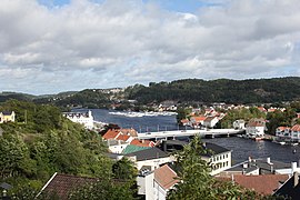
 View of the Mandal harbor
 -
 View of the river Marna
 -
 Mandal bridge


References[edit]
- ^ Store norske leksikon. "Mandalselva" (in Norwegian). Retrieved 2016-11-26.
- ^ Holmqvist, Erik (January 2004). "Flomsonekartprosjektet Flomberegning for Mandalselva (022.Z)" (PDF) (in Norwegian). Norges vassdrags- og energidirektorat. Retrieved 2016-11-26.
- ^ "Mandalselva" (in Norwegian). Norske lakseelver. Archived from the original on 2016-08-12. Retrieved 2016-11-26.
- ^ "River catch of salmon, sea trout and migratory char. Catch from selected rivers. Preliminary figures". Statistisk sentralbyrå. 2015.
External links[edit]
- Mandalselva in Norwegian
- Salmon fishing in Mandalselva (in English)