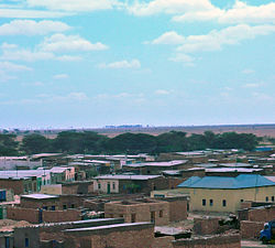
Hingalol
Hingalol | |
|---|---|
Town | |
 | |
| Coordinates: 9°45′16″N 48°18′34″E / 9.75444°N 48.30944°E | |
| Country | |
| Administrative division | Sanaag |
| District | Dhahar |
| Population (2007[2]) | |
| • Total | 45,000 |
| Time zone | UTC+3 (EAT) |
Hingalol or Hingalool (Somali: Xingalool) is a district located in the Sanaag region of Puntland.[3]
Overview[edit]
Hingalol is situated on the Hadeed Plateau of the Sanaag region.[4] Hingalol was established in 1958.[5] A small hamlet, it increased in size and population in the wake of the Somali Civil War and became a full district. In November 2017, Puntland built a military base on the outskirt of the city.[1] In October 2020, Puntland Minister of Education and Minister of Agriculture visited Hingalol to assess needs and support schools and other institutions in the district.[6]
While growing at a faster pace, basic services and government assistance are lacking. In September 2021, the local hospital reported serious cases of COVID-19 in the Hingalol area. For the first time, the Federal Government in Mogadishu delivered essential medical supplies and equipments.[7]
Education[edit]
Hingalol has several academic institutions. According to the Puntland Ministry of Education, there are 11 primary schools in the Hingalol District. Among these are Mindhicir, Shibiraale, Carmale and Darul Qur'aan.[8] Secondary schools in the area include the Hingalol Secondary School. In addition, the new Hingalol Public Library provides a wide range of information and needed library services to users of all ages and abilities, and, in so doing, it remains a significant community asset. It also offers online courses[9]
Notes[edit]
- ^ a b "PUNTLAND OO KA DHAGAX DHIGTAY XINGALOOL SALDHIGII 3-AAD EE GOBOLKA SANAAG LAGA HIRGELINDOONO". puntlandpost.net. 2017-11-25. Retrieved 2021-06-22.
- ^ WFP Somaliland (April 2007). "Puntland Food Security and Vulnerability Assessment" (PDF). Retrieved 2021-06-17.
- ^ "Skills training leads to entrepreneurship in Somalia - Somalia". ReliefWeb. Retrieved 2020-11-19.
- ^ "The predicament of Maakhir territory -By Raz Shirwa | RBC Radio". Archived from the original on 2011-07-25. Retrieved 2011-03-31.
- ^ Simon Mumuli Oduori, Musse Shaie Alim and Nathalie Gomes (February 2006). "Environmental Study of Degradation in the Sool Plateau and Gebi valley: Sanaag region of Northern Somaliland" (PDF). p. 20. Retrieved 2021-06-20.
- ^ "Wasiir ku xigeenka Deegaanka iyo Beeraha Puntland oo kormeertay xarumaha waxbarashada ee Xingalool". idmannews.com. 2020-10-05. Retrieved 2021-06-22.
- ^ "Xaalad caafimaad oo daran oo ka jirta Isbitaalka degmada Xingalool ee gobolka Sanaag". bbc.com. 2021-09-15. Retrieved 2023-01-06.
- ^ "Puntland - Primary schools". Ministry of Education of Puntland. Retrieved 26 May 2013.
- ^ "Puntland - Secondary schools". Ministry of Education of Puntland. Retrieved 26 May 2013.

