
Llallagua
You can help expand this article with text translated from the corresponding article in German. (February 2010) Click [show] for important translation instructions.
|
Llallagua
Llallawa | |
|---|---|
Town | |
 | |
 Seal | |
 Llallagua Location within Bolivia | |
| Coordinates: 18°25′S 66°35′W / 18.417°S 66.583°W | |
| Country | |
| Department | Potosí Department |
| Province | Rafael Bustillo Province |
| Municipality | Llallagua Municipality |
| Canton | Llallagua Canton |
| Government | |
| • Mayor | Tomás Quiróz (Without Fear Movement; elected 2010) |
| • President | Maximo Urquieta Mitma (2007) |
| Elevation | 12,779 ft (3,895 m) |
| Population (2001) | |
| • Total | 20,065 |
| Time zone | UTC-4 (BOT) |
Llallagua (in hispanicized spelling) or Llallawa (Aymara for a monstrous potato (like two potatoes) or animal, Quechua for the god of seed-time during the Inca period)[1][2] is a town in the Potosí Department in Bolivia. It is the seat of the Llallagua Municipality, the third municipal section of the Rafael Bustillo Province.
Geography[edit]
Llallagua features a rare microclimate amidst the semi-arid tundras of Potosí and Oruro, due to its extreme elevation near 4000m. Semi-arid and with average temperatures in its warmest month sitting right on the 11 °C threshold, the city's climate straddles that of the subtropical highland climate (Cwc, according to the Köppen climate classification), with subpolar oceanic characteristics and a cold semi-arid climate (BSk). Summers are cool and wet with daily highs rarely rising above 22 °C, while winters feature cooler days with much colder nights averaging −4 °C. These low temperatures are a result of the extreme precipitation deficit during the winter months with the resulting aridity leading to an increased diurnal temperature variation.
| Climate data for Llallagua, Bolivia (2000−2012) | |||||||||||||
|---|---|---|---|---|---|---|---|---|---|---|---|---|---|
| Month | Jan | Feb | Mar | Apr | May | Jun | Jul | Aug | Sep | Oct | Nov | Dec | Year |
| Mean daily maximum °C (°F) | 17 (63) |
17 (63) |
16 (61) |
17 (63) |
15 (59) |
15 (59) |
14 (57) |
15 (59) |
16 (61) |
18 (64) |
19 (66) |
18 (64) |
19 (66) |
| Daily mean °C (°F) | 9 (48) |
9 (48) |
9 (48) |
8.5 (47.3) |
6.5 (43.7) |
5.5 (41.9) |
5 (41) |
6 (43) |
6.5 (43.7) |
9.5 (49.1) |
10 (50) |
10 (50) |
7.9 (46.2) |
| Mean daily minimum °C (°F) | 3 (37) |
3 (37) |
2 (36) |
0 (32) |
−2 (28) |
−3 (27) |
−4 (25) |
−3 (27) |
−1 (30) |
1 (34) |
2 (36) |
3 (37) |
0.1 (32.2) |
| Average precipitation mm (inches) | 153.0 (6.02) |
125.2 (4.93) |
72.7 (2.86) |
20.5 (0.81) |
2.7 (0.11) |
2.3 (0.09) |
3.8 (0.15) |
6.4 (0.25) |
14.0 (0.55) |
23.3 (0.92) |
36.7 (1.44) |
98.4 (3.87) |
559.0 (22.01) |
| Average precipitation days (≥ 1.0 mm) | 17 | 16 | 12 | 5 | 1 | 0 | 0 | 1 | 2 | 5 | 7 | 14 | 80 |
| Mean daily sunshine hours | 6 | 6 | 7 | 8 | 9 | 9 | 9 | 9 | 8 | 8 | 7 | 7 | 7.75 |
| Source: SENAMHI[3] | |||||||||||||
Gallery[edit]
-
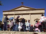 Simon I Patiño Theatre
 -
 Metavauxite, a rare member of the vauxite group. Siglo XX Mine, Llallagua, Bolivia. Size: 4.2 x 1.2 x 1.1 cm.

References[edit]
- ^ Radio San Gabriel, "Instituto Radiofonico de Promoción Aymara" (IRPA) 1993, Republicado por Instituto de las Lenguas y Literaturas Andinas-Amazónicas (ILLLA-A) 2011, Transcripción del Vocabulario de la Lengua Aymara, P. Ludovico Bertonio 1612 (Spanish-Aymara-Aymara-Spanish dictionary)
- ^ Teofilo Laime Ajacopa (2007). Diccionario Bilingüe: Iskay simipi yuyayk’anch: Quechua – Castellano / Castellano – Quechua (PDF). La Paz, Bolivia: futatraw.ourproject.org.
- ^ "SISMET". SENAMHI. Retrieved 19 December 2021.
External links[edit]
![]() Media related to Llallagua at Wikimedia Commons
Media related to Llallagua at Wikimedia Commons
Capital: Potosí | ||
| Provinces |  | |
| Municipalities (and seats) |
| |
| International | |
|---|---|
| National | |