
File:U.S. storms 2012-02-03 1715Z.png

Size of this preview: 800 × 450 pixels. Other resolutions: 320 × 180 pixels | 640 × 360 pixels | 1,024 × 576 pixels | 1,280 × 720 pixels | 1,920 × 1,080 pixels.
Original file (1,920 × 1,080 pixels, file size: 4.03 MB, MIME type: image/png)
| This is a file from the Wikimedia Commons. Information from its description page there is shown below. Commons is a freely licensed media file repository. You can help. |
Summary
| Description |
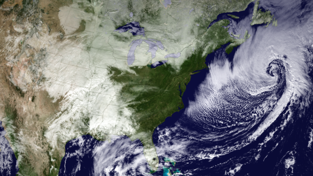
English: Merging both GOES East and West imagery, three weather systems are shown spanning the U.S. To the far west, a stationary system is currently dumping up to two feet of snow over the Denver region. In the South and Plains, a line of severe storms stretches from Texas to Missouri. Over the Atlantic the remnants of an extratropical storm move out to sea. Data from the GOES-15 and -13 satellites were acquired on February 3, 2012 at 1715z. --Caption provided by NOAA |
| Date | |
| Source | http://www.nnvl.noaa.gov/MediaDetail2.php?MediaID=970&MediaTypeID=1 |
| Author | NOAA Environmental Visualization Laboratory |
Licensing
This image is in the public domain because it contains materials that originally came from the U.S. National Oceanic and Atmospheric Administration, taken or made as part of an employee's official duties.
|
File history
Click on a date/time to view the file as it appeared at that time.
| Date/Time | Thumbnail | Dimensions | User | Comment | |
|---|---|---|---|---|---|
| current | 20:13, 31 May 2016 | | 1,920 × 1,080 (4.03 MB) | Master of Time | User created page with UploadWizard |
File usage
The following pages on the English Wikipedia use this file (pages on other projects are not listed):