
File:Tirthapata.JPG

Size of this preview: 506 × 600 pixels. Other resolutions: 202 × 240 pixels | 405 × 480 pixels | 648 × 768 pixels | 864 × 1,024 pixels | 1,727 × 2,048 pixels | 3,280 × 3,889 pixels.
Original file (3,280 × 3,889 pixels, file size: 3.21 MB, MIME type: image/jpeg)
| This is a file from the Wikimedia Commons. Information from its description page there is shown below. Commons is a freely licensed media file repository. You can help. |
Summary
| Description |
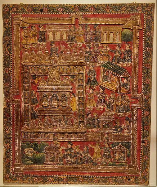
English: The Shwetambara Jains hold five centers of pilgrimage to be most sacred. These places are Shatrunjaya and Girnar in Gujarat, Abu in Rajasthan, Sammeda Shikharji in Jharkhand and mythical Ashtapada in Himalayas. People who are unable to go for the pilgrimage, can achieve its religious merits by viewing cartographical overviews of the pilgrimage site (called Tirthapata). Every year (in Oct-Nov), “Tirthapata” is hung in the vicinity of a Jain temple or at a prepared location for devotees to worship.
This Tirthapata is painted on wood and may have been used as a backdrop for a household shrine. This Tirthapata is from 20th century CE and on display in the "Prince of Wales Museum, Mumbai" (Chhatrapati Shivaji Maharaj Vastu Sangrahalaya). |
| Date | |
| Source | Own work |
| Author | AKS.9955 |
| Camera location | | View this and other nearby images on: OpenStreetMap |
|---|
Licensing
I, the copyright holder of this work, hereby publish it under the following license:
This file is licensed under the Creative Commons Attribution-Share Alike 4.0 International license.
- You are free:
- to share – to copy, distribute and transmit the work
- to remix – to adapt the work
- Under the following conditions:
- attribution – You must give appropriate credit, provide a link to the license, and indicate if changes were made. You may do so in any reasonable manner, but not in any way that suggests the licensor endorses you or your use.
- share alike – If you remix, transform, or build upon the material, you must distribute your contributions under the same or compatible license as the original.
File history
Click on a date/time to view the file as it appeared at that time.
| Date/Time | Thumbnail | Dimensions | User | Comment | |
|---|---|---|---|---|---|
| current | 09:07, 6 November 2015 | | 3,280 × 3,889 (3.21 MB) | AKS.9955 | User created page with UploadWizard |
File usage
The following pages on the English Wikipedia use this file (pages on other projects are not listed):
Global file usage
The following other wikis use this file:
- Usage on bn.wikipedia.org
- Usage on gu.wikipedia.org
- Usage on pa.wikipedia.org
- Usage on ta.wikipedia.org
- Usage on ur.wikipedia.org
- Usage on www.wikidata.org