
File:The Sunken Church, Bramcote - geograph.org.uk - 17713.jpg
Size of this preview: 396 × 599 pixels. Other resolutions: 158 × 240 pixels | 423 × 640 pixels.
Original file (423 × 640 pixels, file size: 70 KB, MIME type: image/jpeg)
| This is a file from the Wikimedia Commons. Information from its description page there is shown below. Commons is a freely licensed media file repository. You can help. |
Summary
| Description |
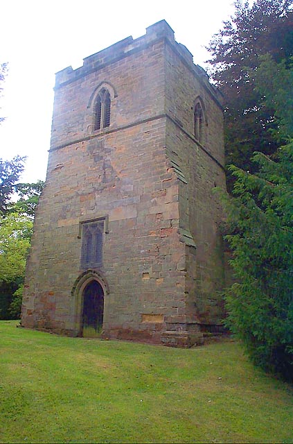
English: 14th-century tower of the former parish church of St Michael, Bramcote, Nottinghamshire. The rest of the church has been lost. It is known locally as the "Sunken Church". |
| Date | |
| Source | From geograph.org.uk |
| Author | Garth Newton |
| Attribution (required by the license) | Garth Newton / The Sunken Church, Bramcote / |
| Camera location | | View this and other nearby images on: OpenStreetMap |
|---|
_heading:180.00&language=en)
| Object location | | View this and other nearby images on: OpenStreetMap |
|---|
_heading:180.00&language=en)
Licensing

|
This image was taken from the Geograph project collection. See this photograph's page on the Geograph website for the photographer's contact details. The copyright on this image is owned by Garth Newton and is licensed for reuse under the Creative Commons Attribution-ShareAlike 2.0 license.
|
This file is licensed under the Creative Commons Attribution-Share Alike 2.0 Generic license.
Attribution: Garth Newton
- You are free:
- to share – to copy, distribute and transmit the work
- to remix – to adapt the work
- Under the following conditions:
- attribution – You must give appropriate credit, provide a link to the license, and indicate if changes were made. You may do so in any reasonable manner, but not in any way that suggests the licensor endorses you or your use.
- share alike – If you remix, transform, or build upon the material, you must distribute your contributions under the same or compatible license as the original.
File history
Click on a date/time to view the file as it appeared at that time.
| Date/Time | Thumbnail | Dimensions | User | Comment | |
|---|---|---|---|---|---|
| current | 05:26, 30 January 2010 | | 423 × 640 (70 KB) | GeographBot | == {{int:filedesc}} == {{Information |description={{en|1=The Sunken Church, Bramcote. A small church existed in Bramcote as early as 1246 and it has been suggested that this tower could have been part of that church. Whatever the truth, the tower standing |
File usage
The following pages on the English Wikipedia use this file (pages on other projects are not listed):
Global file usage
The following other wikis use this file:
- Usage on www.wikidata.org