
File:The Parish Church Of All Saints - geograph.org.uk - 290848 (cropped).jpg
No higher resolution available.
The_Parish_Church_Of_All_Saints_-_geograph.org.uk_-_290848_(cropped).jpg (622 × 457 pixels, file size: 84 KB, MIME type: image/jpeg)
| This is a file from the Wikimedia Commons. Information from its description page there is shown below. Commons is a freely licensed media file repository. You can help. |
This is a photo of listed building number 1063055. |
Summary
| Description |
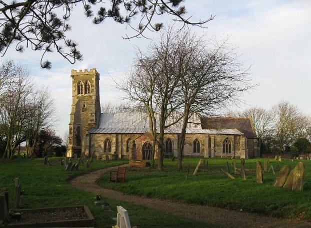
English: The Parish Church Of All Saints Saltfleetby All Saints. The tower really does lean away from the church, as in the photograph. A fillet has been inserted between the tower and the church roof to keep the interior watertight. Saltfleetby St. Clement and Saltfleetby St. Peter are separate hamlets in the area, distinguished by the Saint to whom their churches are dedicated. |
| Date | |
| Source |
This file was derived from: The Parish Church Of All Saints - geograph.org.uk - 290848.jpg |
| Author | Roger Gilbertson |
| Other versions | |
| Attribution (required by the license) | Roger Gilbertson / The Parish Church Of All Saints / |

.jpg)
| Object location | | View this and other nearby images on: OpenStreetMap |
|---|
.jpg¶ms=053.390127_N_0000.187120_E_globe:Earth_class:object_type:object_source:geograph-osgb36(TF4554390371)_heading:337.00&language=en)
Licensing
This file is licensed under the Creative Commons Attribution-Share Alike 2.0 Generic license.
Attribution: Roger Gilbertson
- You are free:
- to share – to copy, distribute and transmit the work
- to remix – to adapt the work
- Under the following conditions:
- attribution – You must give appropriate credit, provide a link to the license, and indicate if changes were made. You may do so in any reasonable manner, but not in any way that suggests the licensor endorses you or your use.
- share alike – If you remix, transform, or build upon the material, you must distribute your contributions under the same or compatible license as the original.
File history
Click on a date/time to view the file as it appeared at that time.
| Date/Time | Thumbnail | Dimensions | User | Comment | |
|---|---|---|---|---|---|
| current | 09:58, 25 November 2018 | | 622 × 457 (84 KB) | Acabashi | File:The Parish Church Of All Saints - geograph.org.uk - 290848.jpg cropped 3 % horizontally, 5 % vertically, rotated 2° using CropTool with precise mode. Straighten. |
File usage
The following pages on the English Wikipedia use this file (pages on other projects are not listed):
Global file usage
The following other wikis use this file:
- Usage on lld.wikipedia.org
- Usage on pl.wikipedia.org
- Usage on sv.wikipedia.org
- Usage on www.wikidata.org
.jpg)