
File:The Mali Empire.jpg

Original file (3,000 × 2,250 pixels, file size: 3.07 MB, MIME type: image/jpeg)
| This is a file from the Wikimedia Commons. Information from its description page there is shown below. Commons is a freely licensed media file repository. You can help. |


Summary
| Description |
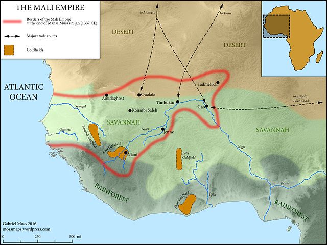
English: The Medieval Mali Empire at the end of Mansa Musa's reign (1337 CE)
Map Sources: Physical elevation representation comes from public-domain SRTM data. Coastlines follow the Barrington Atlas of the Ancient World (Princeton University Press, 2000)--while Mali hardly falls within the time period covered by this atlas, these coastlines omit major harbor construction in the modern period, and are accurate at the scale of the map. Rivers adapted from ESRI user contributions, or traced from satellite imagery. Ecological zones based on "A New Map of Standardized Terrestrial Ecosystems of Africa" (Association of American Geographers, 2013). Historical data drawn from Robert Collins and James Burns, "A History of Sub-Saharan Africa" (Cambridge University Press, 2007) (see esp. p. 86). Adapted and expanded based on lecture materials from Dr. Lisa Lindsay at the University of North Carolina-Chapel Hill, and from this map by wikimedia user Aa77zz: https://commons.wikimedia.org/wiki/File:Trans-Saharan_routes_early.svg |
| Date | |
| Source | Own work |
| Author | Gabriel Moss |
Licensing
- You are free:
- to share – to copy, distribute and transmit the work
- to remix – to adapt the work
- Under the following conditions:
- attribution – You must give appropriate credit, provide a link to the license, and indicate if changes were made. You may do so in any reasonable manner, but not in any way that suggests the licensor endorses you or your use.
- share alike – If you remix, transform, or build upon the material, you must distribute your contributions under the same or compatible license as the original.
File history
Click on a date/time to view the file as it appeared at that time.
| Date/Time | Thumbnail | Dimensions | User | Comment | |
|---|---|---|---|---|---|
| current | 20:14, 13 June 2016 | | 3,000 × 2,250 (3.07 MB) | Mossmaps | User created page with UploadWizard |
File usage
Global file usage
The following other wikis use this file:
- Usage on ar.wikipedia.org
- Usage on arz.wikipedia.org
- Usage on azb.wikipedia.org
- Usage on az.wikipedia.org
- Usage on ba.wikipedia.org
- Usage on bg.wikipedia.org
- Usage on br.wikipedia.org
- Usage on fi.wikipedia.org
- Usage on fr.wikipedia.org
- Usage on gl.wikipedia.org
- Usage on gpe.wikipedia.org
- Usage on ha.wikipedia.org
- Usage on he.wikipedia.org
- Usage on hi.wikipedia.org
- Usage on hy.wikipedia.org
- Usage on hyw.wikipedia.org
- Usage on it.wikipedia.org
- Usage on ja.wikipedia.org
- Usage on ky.wikipedia.org
- Usage on la.wikipedia.org
- Usage on lfn.wikipedia.org
- Usage on pt.wikipedia.org
- Usage on ru.wikipedia.org
- Usage on rw.wikipedia.org
- Usage on simple.wikipedia.org
- Usage on sl.wikipedia.org
- Usage on te.wikipedia.org
- Usage on tr.wikipedia.org
- Usage on uk.wikipedia.org
- Usage on vi.wikipedia.org
- Usage on www.wikidata.org