
File:Taongi Atoll - EVS Precision Map (1-110,000).jpg

Size of this preview: 800 × 558 pixels. Other resolutions: 320 × 223 pixels | 640 × 446 pixels | 1,024 × 714 pixels | 1,258 × 877 pixels.
Original file (1,258 × 877 pixels, file size: 201 KB, MIME type: image/jpeg)
| This is a file from the Wikimedia Commons. Information from its description page there is shown below. Commons is a freely licensed media file repository. You can help. |

|
This map image could be re-created using vector graphics as an SVG file. This has several advantages; see Commons:Media for cleanup for more information. If an SVG form of this image is available, please upload it and afterwards replace this template with
{{vector version available|new image name}}.
It is recommended to name the SVG file “Taongi Atoll - EVS Precision Map (1-110,000).svg”—then the template Vector version available (or Vva) does not need the new image name parameter. |


.jpg)
Summary
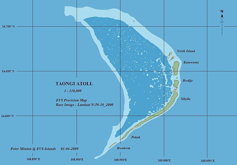
| Description | Taongi (Bokak) Atoll EVS precision map, color coded for vegetation, bare land, reef shallows, lagoon, and open ocean. |
| Date | |
| Source | Taongi Atoll - EVS Precision Map (1-110,000) |
| Author | Mr Minton from San Diego, US |
Licensing
This file is licensed under the Creative Commons Attribution 2.0 Generic license.
- You are free:
- to share – to copy, distribute and transmit the work
- to remix – to adapt the work
- Under the following conditions:
- attribution – You must give appropriate credit, provide a link to the license, and indicate if changes were made. You may do so in any reasonable manner, but not in any way that suggests the licensor endorses you or your use.
| This image was originally posted to Flickr by EVS-Islands at https://www.flickr.com/photos/60042877@N00/3166428015. It was reviewed on 21 March 2009 by FlickreviewR and was confirmed to be licensed under the terms of the cc-by-2.0. |
File history
Click on a date/time to view the file as it appeared at that time.
| Date/Time | Thumbnail | Dimensions | User | Comment | |
|---|---|---|---|---|---|
| current | 02:03, 21 March 2009 | | 1,258 × 877 (201 KB) | Cmholm | {{Information |Description= Taongi (Bokak) Atoll EVS precision map |Source=[http://www.flickr.com/photos/60042877@N00/3166428015/ Taongi Atoll - EVS Precision Map (1-110,000)] |Date=January 04, 2009 at 08:27 |Author=[http://www.flickr.com/people/60042877@ |
File usage
The following pages on the English Wikipedia use this file (pages on other projects are not listed):
Global file usage
The following other wikis use this file:
- Usage on cs.wikipedia.org
- Usage on de.wikipedia.org
- Usage on es.wikipedia.org
- Usage on eu.wikipedia.org
- Usage on fa.wikipedia.org
- Usage on ja.wikipedia.org
- Usage on ko.wikipedia.org
- Usage on lt.wikipedia.org
- Usage on mk.wikipedia.org
- Usage on pl.wikipedia.org
- Usage on pt.wikipedia.org
- Usage on ru.wikipedia.org
- Usage on sv.wikipedia.org
- Usage on zh.wikipedia.org
.jpg)