
File:Sharpie stern with dhingies 183.JPG

Size of this preview: 800 × 600 pixels. Other resolutions: 320 × 240 pixels | 640 × 480 pixels | 1,024 × 768 pixels | 1,280 × 960 pixels | 2,048 × 1,536 pixels.
Original file (2,048 × 1,536 pixels, file size: 1.07 MB, MIME type: image/jpeg)
| This is a file from the Wikimedia Commons. Information from its description page there is shown below. Commons is a freely licensed media file repository. You can help. |
Summary
| Camera location | | View this and other nearby images on: OpenStreetMap |
|---|
| Description |
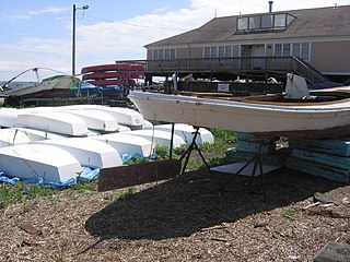
English: A view of the stern of a sharpie layed up in front of the Sound School on South Water Street in the City Point neighborhood of New Haven, Connecticut, USA. This view shows a couple of the distinct features of the Sharpie design: the rounded stern (constructed with barrel staving between chine and carlin in the days of wooden boats) and the reversible rudder. The rudder in particular could be temporarily reversed to allow for the hauling of oyster dredge equipment up over the stern without fouling. The helm would feel touchy and skittish (as well as exert more torque back to the skipper) in reverse direction, hence it was not used in the reversed orientation all the time (the photograph shows the conventional rudder orientation). Another aspect of the sharpie rudder design is its vertical travel capability. When traversing a particularly shallow shoal the rudder shaft could be lifted, to allow control and an unusually shallow draft at the stern. The vertical travel might also help facilitate easier beaching when desired. |
| Date | |
| Source | Own work |
| Author | Pedro Xing |
Licensing
I, the copyright holder of this work, hereby publish it under the following license:
| This file is made available under the Creative Commons CC0 1.0 Universal Public Domain Dedication. | |
| The person who associated a work with this deed has dedicated the work to the public domain by waiving all of their rights to the work worldwide under copyright law, including all related and neighboring rights, to the extent allowed by law. You can copy, modify, distribute and perform the work, even for commercial purposes, all without asking permission.
|
File history
Click on a date/time to view the file as it appeared at that time.
| Date/Time | Thumbnail | Dimensions | User | Comment | |
|---|---|---|---|---|---|
| current | 02:09, 12 May 2012 | | 2,048 × 1,536 (1.07 MB) | Pedro Xing |
File usage
The following pages on the English Wikipedia use this file (pages on other projects are not listed):