
File:Remains of former canal bridge, Wrockwardine Wood - geograph.org.uk - 1352074.jpg
No higher resolution available.
Remains_of_former_canal_bridge,_Wrockwardine_Wood_-_geograph.org.uk_-_1352074.jpg (640 × 451 pixels, file size: 93 KB, MIME type: image/jpeg)
| This is a file from the Wikimedia Commons. Information from its description page there is shown below. Commons is a freely licensed media file repository. You can help. |
Summary
| Description |
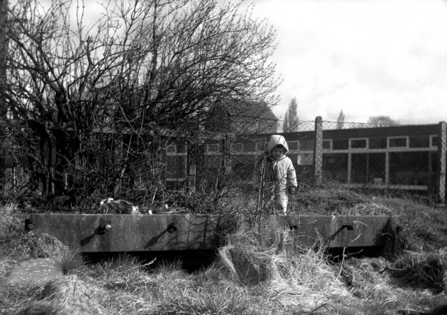
English: Remains of former canal bridge, Wrockwardine Wood The child here is standing on the deck of a former canal bridge. The canal has been filled in, although had I got here about five years earlier it would probably have still been in water. This was the Wombridge Canal, opened in 1788, which extended westwards from the previously isolated Donnington Wood Canal to Wombridge, and later about 1795 was connected by the Trench Inclined Plane to the Shrewsbury Canal at Trench Lock. The canal here was used by tub boats, measuring about 20ft x 6ft, and with capacity for about 8 tons of coal. The main traffic was coal, westwards from the collieries at Donnington Wood to Shrewsbury. At Trench Lock, the cargo was transferred from the tub boats into special 'narrow' narrowboats for onward shipment to Shrewsbury. Unfortunately the zombies of the Telford New Town development agency ignored all the rich industrial heritage in this area, and it has now all disappeared submerged in a sea of mediocrity. |
| Date | |
| Source | From geograph.org.uk |
| Author | Dr Neil Clifton |
| Attribution (required by the license) | Dr Neil Clifton / Remains of former canal bridge, Wrockwardine Wood / |
| Camera location | | View this and other nearby images on: OpenStreetMap |
|---|
_heading:0.00&language=en)
| Object location | | View this and other nearby images on: OpenStreetMap |
|---|
_heading:0.00&language=en)
Licensing

|
This image was taken from the Geograph project collection. See this photograph's page on the Geograph website for the photographer's contact details. The copyright on this image is owned by Dr Neil Clifton and is licensed for reuse under the Creative Commons Attribution-ShareAlike 2.0 license.
|
This file is licensed under the Creative Commons Attribution-Share Alike 2.0 Generic license.
Attribution: Dr Neil Clifton
- You are free:
- to share – to copy, distribute and transmit the work
- to remix – to adapt the work
- Under the following conditions:
- attribution – You must give appropriate credit, provide a link to the license, and indicate if changes were made. You may do so in any reasonable manner, but not in any way that suggests the licensor endorses you or your use.
- share alike – If you remix, transform, or build upon the material, you must distribute your contributions under the same or compatible license as the original.
File history
Click on a date/time to view the file as it appeared at that time.
| Date/Time | Thumbnail | Dimensions | User | Comment | |
|---|---|---|---|---|---|
| current | 08:38, 28 February 2011 | | 640 × 451 (93 KB) | GeographBot | == {{int:filedesc}} == {{Information |description={{en|1=Remains of former canal bridge, Wrockwardine Wood The child here is standing on the deck of a former canal bridge. The canal has been filled in, although had I got here about five years earlier it |
File usage
The following pages on the English Wikipedia use this file (pages on other projects are not listed):
Global file usage
The following other wikis use this file:
- Usage on arz.wikipedia.org
- Usage on www.wikidata.org