
File:PazSoldan.jpg

Original file (3,532 × 5,210 pixels, file size: 2.87 MB, MIME type: image/jpeg)
| This is a file from the Wikimedia Commons. Information from its description page there is shown below. Commons is a freely licensed media file repository. You can help. |
| Description |
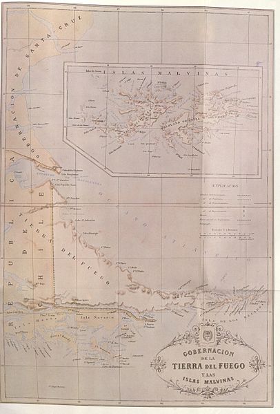
Map from the Argentine Republic Geographic Atlas - 1887. This geographic Atlas was made up under the direction of the geographer Mariano Felipe Paz Soldan. Shown here is the plate XXVI of the Atlas headed "Governship of Tierra del Fuego and the Malvinas Islands". On this map the international boundary is traced along the centre of the Beagle Channel, indicating Picton, Nueva and Lennox and all the other islands and islets extending as far as Cape Horn as being under Chilean sovereingty |
||||
| Date | |||||
| Source | El Conflicto del Beagle, edited by the chilean Foreign Affairs Office, 1978, Switzerland. | ||||
| Author | Paz Soldan | ||||
| Permission (Reusing this file) |
|
||||
File history
Click on a date/time to view the file as it appeared at that time.
| Date/Time | Thumbnail | Dimensions | User | Comment | |
|---|---|---|---|---|---|
| current | 01:09, 6 November 2007 | | 3,532 × 5,210 (2.87 MB) | Keysanger | {{Information |Description=Paz Soldan |Source=El Conflicto del Beagle, edited by the chilean Foreign Affairs Office, 1978, Switzerland. |Date=1887 |Author=Paz Soldan |Permission={{PD-Old}} |other_versions= }} Category:Maps of Chile [[Category:Maps of |