
File:Orlando-Kissimmee Florida Metropolitan Statistical Area.svg

Size of this PNG preview of this SVG file: 619 × 600 pixels. Other resolutions: 248 × 240 pixels | 495 × 480 pixels | 793 × 768 pixels | 1,057 × 1,024 pixels | 2,113 × 2,048 pixels | 1,001 × 970 pixels.
Original file (SVG file, nominally 1,001 × 970 pixels, file size: 112 KB)
| This is a file from the Wikimedia Commons. Information from its description page there is shown below. Commons is a freely licensed media file repository. You can help. |
Summary
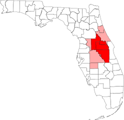
| Description | Map of Florida showing the Orlando-Kissimmee Florida Metropolitan Statistical Area highlighted in red, along with the rest of the Orlando-Deltona-Daytona Beach Combined Statistical Area highlighted in light red. Based on information from the US Census Bureau and created with a custom script. |
| Date | |
| Source | Own work |
| Author | Arkyan |
Licensing
I, the copyright holder of this work, hereby publish it under the following licenses:

|
Permission is granted to copy, distribute and/or modify this document under the terms of the GNU Free Documentation License, Version 1.2 or any later version published by the Free Software Foundation; with no Invariant Sections, no Front-Cover Texts, and no Back-Cover Texts. A copy of the license is included in the section entitled GNU Free Documentation License. |
This file is licensed under the Creative Commons Attribution-Share Alike 3.0 Unported, 2.5 Generic, 2.0 Generic and 1.0 Generic license.
- You are free:
- to share – to copy, distribute and transmit the work
- to remix – to adapt the work
- Under the following conditions:
- attribution – You must give appropriate credit, provide a link to the license, and indicate if changes were made. You may do so in any reasonable manner, but not in any way that suggests the licensor endorses you or your use.
- share alike – If you remix, transform, or build upon the material, you must distribute your contributions under the same or compatible license as the original.
You may select the license of your choice.
File history
Click on a date/time to view the file as it appeared at that time.
| Date/Time | Thumbnail | Dimensions | User | Comment | |
|---|---|---|---|---|---|
| current | 05:22, 4 July 2019 | | 1,001 × 970 (112 KB) | Floridian | Updated map to reflect new boundaries of the Orlando-Lakeland-Deltona, FL Combined Statistical Area (addition of Lakeland-Winter Haven, FL Metropolitan Statistical Area and Wauchula, FL Micropolitan Statistical Area). Edited using Method of Action web editor. |
| 15:21, 10 October 2007 |  | 1,001 × 970 (252 KB) | Shereth | == Summary == {{Information |Description=Map of Florida showing the Orlando-Kissimmee Florida Metropolitan Statistical Area highlighted in red, along with the rest of the Orland | |
| 15:20, 10 October 2007 |  | 1,001 × 970 (252 KB) | Shereth | == Summary == {{Information |Description=Map of Florida showing the Orlando-Kissimmee Florida Metropolitan Statistical Area highlighted in red, along with the rest of the Orland | |
| 15:20, 10 October 2007 |  | 1,001 × 970 (252 KB) | Shereth | == Summary == {{Information |Description=Map of Florida showing the Orlando-Kissimmee Florida Metropolitan Statistical Area highlighted in red, along with the rest of the Orland |
File usage
The following pages on the English Wikipedia use this file (pages on other projects are not listed):
- Addition Financial Arena
- AdventHealth
- AdventHealth Celebration
- AdventHealth Heart of Florida
- AdventHealth Lake Wales
- AdventHealth Nicholson Center
- AdventHealth Orlando
- AdventHealth Palm Coast Parkway
- Alafaya, Florida
- Altamonte Springs, Florida
- Azalea Park, Florida
- Buenaventura Lakes, Florida
- Camping World Stadium
- Casselberry, Florida
- Central Florida Future
- Clermont, Florida
- Conway, Florida
- Daytona State College
- DeBary, Florida
- DeLand, Florida
- DeLand Municipal Airport
- Deltona, Florida
- Dr. Phillips, Florida
- Dr. Phillips Center for the Performing Arts
- Eustis, Florida
- FBC Mortgage Stadium
- Fairview Shores, Florida
- Florida Today
- Four Corners, Florida
- Goldenrod, Florida
- Greater Orlando
- Holy Land Experience
- Horizon West, Florida
- Hunter's Creek, Florida
- Kia Center
- Kissimmee, Florida
- Kissimmee Gateway Airport
- Lady Lake, Florida
- Lake Butler, Orange County, Florida
- Lake County, Florida
- Lake Mary, Florida
- Lake Nona Medical City
- Lake–Sumter State College
- Leesburg, Florida
- Lockhart, Florida
- Longwood, Florida
- Maitland, Florida
- Meadow Woods, Florida
- Mount Dora, Florida
- Oak Ridge, Florida
- Ocoee, Florida
- Orange City, Florida
- Orange County, Florida
- Orlando, Florida
- Orlando Executive Airport
- Orlando Eye
- Orlando Health
- Orlando International Airport
- Orlando International Airport Intermodal Terminal
- Orlando Museum of Art
- Orlando Sanford International Airport
- Orlando Science Center
- Orlando Sentinel
- Osceola News-Gazette
- Oviedo, Florida
- Palm Coast, Florida
- Pine Castle, Florida
- Pine Hills, Florida
- Poinciana, Florida
- Sanford, Florida
- Seminole County, Florida
- Seminole State College of Florida
- Southchase, Florida
- Spook Hill
- St. Cloud, Florida
- Tavares, Florida
- The Daytona Beach News-Journal
- The Villages, Florida
- The Villages Daily Sun
- Timeline of Orlando, Florida
- University, Orange County, Florida
- University of Central Florida
- Valencia College
- WESH
- WFTV
- WKCF
- WKMG-TV
- WOFL
- WRBW
- WUCF-TV
- Wekiwa Springs, Florida
- Windermere, Florida
- Winter Garden, Florida
- Winter Park, Florida
- Winter Springs, Florida
- User:Catfurball/AdventHealth Lakeland
- User:Jasap/sandbox
- User talk:Shereth/Archive03
- Template:Metro Orlando
Global file usage
The following other wikis use this file:
- Usage on de.wikipedia.org
- Usage on es.wikipedia.org
- Usage on fa.wikipedia.org
- Usage on fr.wikipedia.org
- Usage on it.wikivoyage.org
- Usage on ru.wikipedia.org
- Usage on ur.wikipedia.org
- Usage on www.wikidata.org