
File:Old Wyldes - geograph.org.uk - 1269497.jpg
No higher resolution available.
Old_Wyldes_-_geograph.org.uk_-_1269497.jpg (640 × 480 pixels, file size: 110 KB, MIME type: image/jpeg)
| This is a file from the Wikimedia Commons. Information from its description page there is shown below. Commons is a freely licensed media file repository. You can help. |
Summary
| Description |
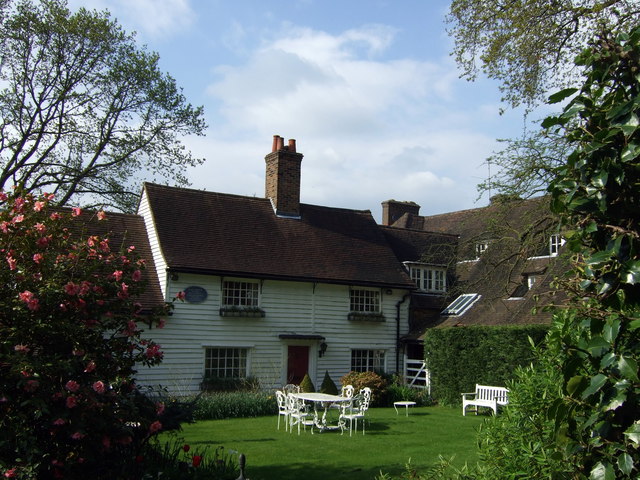
English: Old Wyldes The weatherboarded section of Wyldes Farm which adjoins to the right. The name goes back to the C15 when the farm owned a large estate of what was then open country. Much of this (purchased by Eton College) later went to form the Hampstead Heath Extension.
The house became the home of artists and well-heeled bohemians: the painter John Linnell (1792-1882) lived here and was visited by Blake, Morland and Dickens; the Hampstead Fabian-turned-anarchist Charlotte Wilson (1854-1944) entertained Prince Peter Kropokin and others here in the 1880s; and the architect of Hampstead Garden Suburb, Raymond Unwin, lived here from 1906 to his death in 1940. |
| Date | |
| Source | From geograph.org.uk |
| Author | ceridwen |
| Attribution (required by the license) | ceridwen / Old Wyldes / |
| Camera location | | View this and other nearby images on: OpenStreetMap |
|---|
_heading:270.00&language=en)
| Object location | | View this and other nearby images on: OpenStreetMap |
|---|
_heading:270.00&language=en)
This is a photo of listed building number 1359046. |
Licensing

|
This image was taken from the Geograph project collection. See this photograph's page on the Geograph website for the photographer's contact details. The copyright on this image is owned by ceridwen and is licensed for reuse under the Creative Commons Attribution-ShareAlike 2.0 license.
|
This file is licensed under the Creative Commons Attribution-Share Alike 2.0 Generic license.
Attribution: ceridwen
- You are free:
- to share – to copy, distribute and transmit the work
- to remix – to adapt the work
- Under the following conditions:
- attribution – You must give appropriate credit, provide a link to the license, and indicate if changes were made. You may do so in any reasonable manner, but not in any way that suggests the licensor endorses you or your use.
- share alike – If you remix, transform, or build upon the material, you must distribute your contributions under the same or compatible license as the original.
| Annotations | This image is annotated: View the annotations at Commons |
File history
Click on a date/time to view the file as it appeared at that time.
| Date/Time | Thumbnail | Dimensions | User | Comment | |
|---|---|---|---|---|---|
| current | 00:05, 27 February 2011 | | 640 × 480 (110 KB) | GeographBot | == {{int:filedesc}} == {{Information |description={{en|1=Old Wyldes The weatherboarded section of Wyldes Farm which adjoins to the right. The name goes back to the C15 when the farm owned a large estate of what was then open country. Much of this (purcha |
File usage
The following pages on the English Wikipedia use this file (pages on other projects are not listed):
Global file usage
The following other wikis use this file:
- Usage on www.wikidata.org