
File:Nottingham Midland Station, Nottingham - geograph.org.uk - 1578413.jpg
No higher resolution available.
Nottingham_Midland_Station,_Nottingham_-_geograph.org.uk_-_1578413.jpg (640 × 480 pixels, file size: 86 KB, MIME type: image/jpeg)
| This is a file from the Wikimedia Commons. Information from its description page there is shown below. Commons is a freely licensed media file repository. You can help. |
| Description |
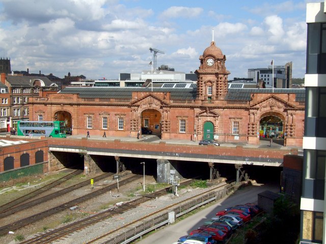
English: Nottingham Midland Station, Nottingham A line from Nottingham to Derby was opened by the Midland Counties Railway in 1839, with its station at the Meadows. The following year the line progressed to Leicester and on towards London via Rugby. Under the new Midland Railway, a line was opened to Lincoln in 1846. In 1848 the Meadows station was replaced by one in Station Street and the Meadows became a goods depot.
The GN line was the first to use the new station, but went on to build its own in London Road in 1857. The Midland opened other lines and traffic increased, which necessitated a rebuild in 1904, the frontage of which was designed by A E Lambert. It faces Carrington Street, but previously, the entrance was in Station Street. In 1900, the GCR opened the Victoria Station to the north and their route was elevated over the Midland's. |
||
| Date | |||
| Source | From geograph.org.uk | ||
| Author | Dave Hitchborne | ||
| Permission (Reusing this file) |
This file is licensed under the Creative Commons Attribution-Share Alike 2.0 Generic license. Attribution: Dave Hitchborne
|

| Camera location | | View this and other nearby images on: OpenStreetMap |
|---|
_heading:67.00&language=en)
| Object location | | View this and other nearby images on: OpenStreetMap |
|---|
_heading:67.00&language=en)
File history
Click on a date/time to view the file as it appeared at that time.
| Date/Time | Thumbnail | Dimensions | User | Comment | |
|---|---|---|---|---|---|
| current | 21:03, 3 March 2011 | | 640 × 480 (86 KB) | GeographBot | == {{int:filedesc}} == {{Information |description={{en|1=Nottingham Midland Station, Nottingham A line from Nottingham to Derby was opened by the Midland Counties Railway in 1839, with its station at the Meadows. The following year the line progressed to |
File usage
The following pages on the English Wikipedia use this file (pages on other projects are not listed):
Global file usage
The following other wikis use this file:
- Usage on cy.wikipedia.org
- Usage on fa.wikipedia.org