
File:NZ-Buller R.png

Size of this preview: 530 × 599 pixels. Other resolutions: 212 × 240 pixels | 425 × 480 pixels | 679 × 768 pixels | 1,234 × 1,395 pixels.
Original file (1,234 × 1,395 pixels, file size: 255 KB, MIME type: image/png)
| This is a file from the Wikimedia Commons. Information from its description page there is shown below. Commons is a freely licensed media file repository. You can help. |
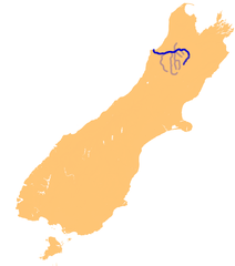
| Description | Location map of Buller river, Tasman and West Coast regions, South Island, New Zealand | ||
| Source | en:wikipedia | ||
| Author | James Dignan | ||
| Permission (Reusing this file) |
|
File history
Click on a date/time to view the file as it appeared at that time.
| Date/Time | Thumbnail | Dimensions | User | Comment | |
|---|---|---|---|---|---|
| current | 11:32, 12 November 2006 | | 1,234 × 1,395 (255 KB) | 2000 | {{Information |Description=Location map of Buller river, Tasman and West Coast regions, South Island, New Zealand |Source=en:wikipedia |Date= |Author=James Dignan |Permission={{PD-user-w|:en:wikipedia|en:wikipedia|Grutness}} |other_versions= }} [[Categor |
File usage
The following pages on the English Wikipedia use this file (pages on other projects are not listed):
Global file usage
The following other wikis use this file:
- Usage on fr.wikipedia.org
- Usage on pl.wikipedia.org