File:Mount Whitecap and Ladd Peak.jpg

Page contents not supported in other languages.
This is a file from the Wikimedia Commons
From Wikipedia, the free encyclopedia

Original file(1,582 × 1,392 pixels, file size: 530 KB, MIME type: image/jpeg)

Summary

Description
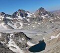
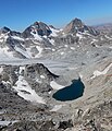
English: Mount Whitecap (left) and Ladd Peak (right) with Mammoth Glacier below. View from northeast. Wind River Range, Wyoming.
Date
Source https://www.flickr.com/photos/bridgerteton/47008184701/
Author Bridger Teton NF
Camera location43° 10′ 54.53″ N, 109° 40′ 30.11″ W Kartographer map based on OpenStreetMap.View this and other nearby images on: OpenStreetMapinfo

Licensing

This image was originally posted to Flickr by Bridger-Teton NF at https://flickr.com/photos/85886752@N06/47008184701. It was reviewed on 17 July 2023 by FlickreviewR 2 and was confirmed to be licensed under the terms of the Public Domain Mark.

17 July 2023

Public domain
This image is a work of the Forest Service of the United States Department of Agriculture. As a work of the U.S. federal government, the image is in the public domain.

Captions

Add a one-line explanation of what this file represents

Items portrayed in this file

depicts

image/jpeg

643658c557777507c6c5665e7182d6b997e3a008

542,400 byte

1,392 pixel

1,582 pixel

43°10'54.534"N, 109°40'30.108"W

File history

Click on a date/time to view the file as it appeared at that time.

Date/TimeThumbnailDimensionsUserComment
current09:14, 17 July 2023Thumbnail for version as of 09:14, 17 July 20231,582 × 1,392 (530 KB)Ron Clausencrop, exposure
09:08, 17 July 2023Thumbnail for version as of 09:08, 17 July 20231,608 × 1,872 (1.94 MB)Ron ClausenUploaded a work by Bridger Teton NF from https://www.flickr.com/photos/bridgerteton/47008184701/ with UploadWizard
The following pages on the English Wikipedia use this file (pages on other projects are not listed):

Metadata