
File:Memorial to the Aer Lingus crash of January 1952 - 1784244.jpg
Size of this preview: 800 × 558 pixels. Other resolutions: 320 × 223 pixels | 640 × 446 pixels | 1,024 × 714 pixels.
Original file (1,024 × 714 pixels, file size: 224 KB, MIME type: image/jpeg)
| This is a file from the Wikimedia Commons. Information from its description page there is shown below. Commons is a freely licensed media file repository. You can help. |
Summary
| Description |
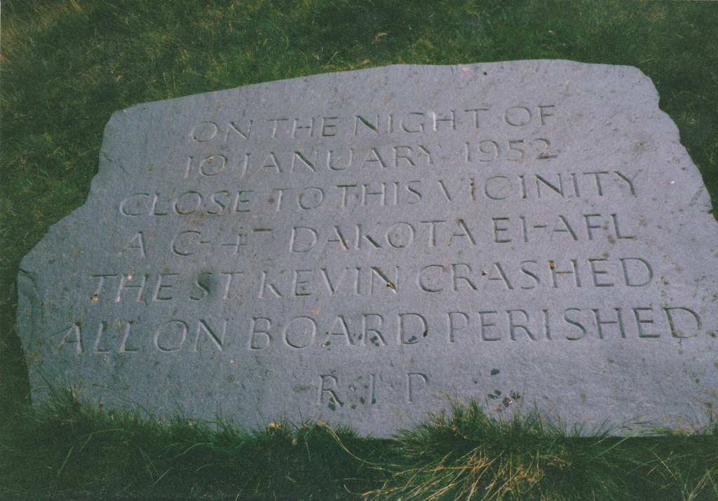
English: Memorial to the passengers and crew of Aer Lingus crash of 10 January 1952, 4 km from Plas Gwynant, Gwynedd, Great Britain.
The Douglas DC-3 (named 'Saint Kevin') owned by Aer Lingus left RAF Northolt, London at 17:25 on 10th January, 1952 on a flight to Dublin. Radio contact with the plane was lost shortly after the pilot requested permission from Dublin control at around 19:15 to descend from 6500 ft to 4500 ft. A board of inquiry came to the conclusion that the descending plane encountered a "powerful down-current of air on the lee side of Snowdon which forced the aircraft down into an area of very great turbulence .." which led the pilot, Capt Keohane, to "lose control.." Even in mid summer, the Cwm Edno bog at 1.500ft, is an inhospitable place. The conditions on that night in January, 1952 were absolutely atrocious. I remember at the time Police Constable Jones, stationed at Deiniolen, describing the scene of utter devastation which met officers who had had to climb for almost an hour to the site from the Llyn Gwynant road, how sections of the wreckage and many bodies had been sucked into the muddy bog and how a little child's doll had on impact been thrown clear of the burning wreckage, something which upset the men greatly. |
| Date | |
| Source | From this image at geograph.org.uk; transferred by User:RHaworth using geograph_org2commons. |
| Author | Eric Jones |
| Other versions |
|
| Attribution (required by the license) | Eric Jones / Memorial to the passengers and crew of Aer Lingus crash of 10th January 1952 / |


| Camera location | | View this and other nearby images on: OpenStreetMap |
|---|
| Object location | | View this and other nearby images on: OpenStreetMap |
|---|
_region:GB-GBN_heading:157.00&language=en)
Licensing

|
This image was taken from the Geograph project collection. See this photograph's page on the Geograph website for the photographer's contact details. The copyright on this image is owned by Eric Jones and is licensed for reuse under the Creative Commons Attribution-ShareAlike 2.0 license.
|
This file is licensed under the Creative Commons Attribution-Share Alike 2.0 Generic license.
Attribution: Eric Jones
- You are free:
- to share – to copy, distribute and transmit the work
- to remix – to adapt the work
- Under the following conditions:
- attribution – You must give appropriate credit, provide a link to the license, and indicate if changes were made. You may do so in any reasonable manner, but not in any way that suggests the licensor endorses you or your use.
- share alike – If you remix, transform, or build upon the material, you must distribute your contributions under the same or compatible license as the original.
File history
Click on a date/time to view the file as it appeared at that time.
| Date/Time | Thumbnail | Dimensions | User | Comment | |
|---|---|---|---|---|---|
| current | 22:49, 27 September 2010 | | 1,024 × 714 (224 KB) | File Upload Bot (Magnus Manske) | == {{int:filedesc}} == {{Information |Description={{en|1=Memorial to the passengers and crew of Aer Lingus crash of 10th January 1952, 4 km from Plas Gwynant, Gwynedd, Great Britain. The Douglas DC-3 (named 'Saint Kevin') owned by Aer Lingus lef |
File usage
The following pages on the English Wikipedia use this file (pages on other projects are not listed):
Global file usage
The following other wikis use this file:
- Usage on hu.wikipedia.org
- Usage on ja.wikipedia.org
- Usage on tr.wikipedia.org