
File:Ka argo.svg

Size of this PNG preview of this SVG file: 800 × 235 pixels. Other resolutions: 320 × 94 pixels | 640 × 188 pixels | 1,024 × 301 pixels | 1,280 × 376 pixels | 2,560 × 753 pixels | 966 × 284 pixels.
Original file (SVG file, nominally 966 × 284 pixels, file size: 335 KB)
| This is a file from the Wikimedia Commons. Information from its description page there is shown below. Commons is a freely licensed media file repository. You can help. |
Summary
| Description |
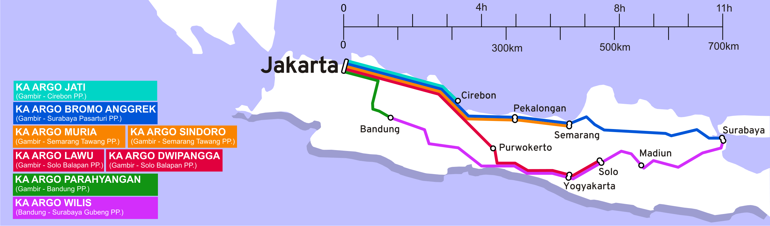
English: Schematic Map of Kereta Api, Argo train network |
| Date | |
| Source | Own work |
| Author | Michaeltrs |
Derived from data retrieved from http://infoka.kereta-api.com/ archive copy at the Wayback Machine 21 July 2008 Base map adapted and simplified from http://commons.wikimedia.org/wiki/Image:Indonesia_blank_map.svg
Licensing
I, the copyright holder of this work, hereby publish it under the following licenses:
This file is licensed under the Creative Commons Attribution-Share Alike 3.0 Unported license.
- You are free:
- to share – to copy, distribute and transmit the work
- to remix – to adapt the work
- Under the following conditions:
- attribution – You must give appropriate credit, provide a link to the license, and indicate if changes were made. You may do so in any reasonable manner, but not in any way that suggests the licensor endorses you or your use.
- share alike – If you remix, transform, or build upon the material, you must distribute your contributions under the same or compatible license as the original.

|
Permission is granted to copy, distribute and/or modify this document under the terms of the GNU Free Documentation License, Version 1.2 or any later version published by the Free Software Foundation; with no Invariant Sections, no Front-Cover Texts, and no Back-Cover Texts. A copy of the license is included in the section entitled GNU Free Documentation License. |
You may select the license of your choice.
File history
Click on a date/time to view the file as it appeared at that time.
| Date/Time | Thumbnail | Dimensions | User | Comment | |
|---|---|---|---|---|---|
| current | 14:47, 8 July 2016 | 966 × 284 (335 KB) | Alzena2nd | Updating information (Memperbarui informasi). | |
| 14:43, 28 July 2010 | 904 × 303 (427 KB) | Goldsztajn | edits to correct rending problems | ||
| 11:55, 21 July 2008 | 904 × 303 (71 KB) | Michaeltrs | {{Information |Description= |Source= |Date= |Author= |Permission= |other_versions= }} | ||
| 10:19, 21 July 2008 | 904 × 336 (61 KB) | Michaeltrs | {{Information |Description= |Source= |Date= |Author= |Permission= |other_versions= }} | ||
| 09:59, 21 July 2008 | 700 × 266 (73 KB) | Michaeltrs | {{Information |Description= |Source= |Date= |Author= |Permission= |other_versions= }} | ||
| 09:56, 21 July 2008 | 292 × 111 (71 KB) | Michaeltrs | {{Information |Description= |Source= |Date= |Author= |Permission= |other_versions= }} | ||
| 09:46, 21 July 2008 |  | 1,052 × 744 (71 KB) | Michaeltrs | {{Information |Description={{en|1=Schematic Map of Kereta Api, Argo train network}} |Source=Own work by uploader |Author=Michaeltrs |Date=21 July 2008 |Permission= |other_versions= }} Derived from data retrieved from http://infoka.kere |
File usage
The following pages on the English Wikipedia use this file (pages on other projects are not listed):
Global file usage
The following other wikis use this file:
- Usage on de.wikipedia.org
- Usage on es.wikipedia.org
- Usage on fr.wikipedia.org
- Usage on id.wikipedia.org
- Usage on ja.wikipedia.org
- Usage on th.wikipedia.org
- Usage on zh.wikipedia.org