
File:Induan map.jpg

Size of this preview: 800 × 465 pixels. Other resolutions: 320 × 186 pixels | 640 × 372 pixels | 1,052 × 612 pixels.
Original file (1,052 × 612 pixels, file size: 243 KB, MIME type: image/jpeg)
| This is a file from the Wikimedia Commons. Information from its description page there is shown below. Commons is a freely licensed media file repository. You can help. |
Summary
| Description |
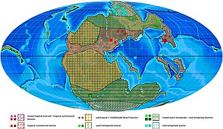
English: Induan plant macrofossil localities with associated biomes and estimated biome extension areas projected on a palaeogeographic reconstruction for the late Permian–Early Triassic (250 Ma). Dotted symbols indicate calculated biomes, empty symbols indicate manual biomes. |
| Date | |
| Source | https://doi.org/10.3389/feart.2020.613350 |
| Author | Hendrik Nowak, Christian Vérard, Evelyn Kustatscher |
Licensing
This file is licensed under the Creative Commons Attribution 4.0 International license.
- You are free:
- to share – to copy, distribute and transmit the work
- to remix – to adapt the work
- Under the following conditions:
- attribution – You must give appropriate credit, provide a link to the license, and indicate if changes were made. You may do so in any reasonable manner, but not in any way that suggests the licensor endorses you or your use.
File history
Click on a date/time to view the file as it appeared at that time.
| Date/Time | Thumbnail | Dimensions | User | Comment | |
|---|---|---|---|---|---|
| current | 23:45, 16 June 2022 | | 1,052 × 612 (243 KB) | Dunkleosteus77 | Uploaded a work by Hendrik Nowak, Christian Vérard, Evelyn Kustatscher from https://doi.org/10.3389/feart.2020.613350 with UploadWizard |
File usage
The following pages on the English Wikipedia use this file (pages on other projects are not listed):