
File:IndigoBuntingRangeMapCropped.png
No higher resolution available.
IndigoBuntingRangeMapCropped.png (360 × 330 pixels, file size: 6 KB, MIME type: image/png)
| This is a file from the Wikimedia Commons. Information from its description page there is shown below. Commons is a freely licensed media file repository. You can help. |
Summary
| Description |
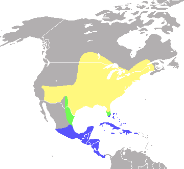
English: Range map of the Indigo Bunting, Passerina cyanea, based on the map at Nature Serve.org [1] and the map in A Field Guide to the Birds East of the Rockies by Roger Tory Peterson. Cropped version.
Yellow indicates summer range, green indicates migratory range, blue indicates winter range |
| Date | |
| Source | Own work |
| Author | Hey jude, don't let me down |
Licensing
| I, the copyright holder of this work, release this work into the public domain. This applies worldwide. In some countries this may not be legally possible; if so: I grant anyone the right to use this work for any purpose, without any conditions, unless such conditions are required by law. |
File history
Click on a date/time to view the file as it appeared at that time.
| Date/Time | Thumbnail | Dimensions | User | Comment | |
|---|---|---|---|---|---|
| current | 12:47, 15 July 2008 | | 360 × 330 (6 KB) | Hey jude, don't let me down | {{Information |Description={{en|1=Range map of the Indigo Bunting, ''Passerina cyanea'', based on the map at Nature Serve.org [http://www.natureserve.org/infonatura/servlet/InfoNatura?searchName=Passerina+cyanea#rangemap] and the map in ''A Field Guide to |
File usage
The following pages on the English Wikipedia use this file (pages on other projects are not listed):
Global file usage
The following other wikis use this file:
- Usage on ast.wikipedia.org
- Usage on bg.wikipedia.org
- Usage on ca.wikipedia.org
- Usage on ceb.wikipedia.org
- Usage on cs.wikipedia.org
- Usage on cy.wikipedia.org
- Usage on de.wikipedia.org
- Usage on es.wikipedia.org
- Usage on eu.wikipedia.org
- Usage on fa.wikipedia.org
- Usage on fr.wikipedia.org
- Usage on hu.wikipedia.org
- Usage on nl.wikipedia.org
- Usage on nv.wikipedia.org
- Usage on pl.wikipedia.org
- Usage on ro.wikipedia.org
- Usage on ru.wikipedia.org
- Usage on species.wikimedia.org
- Usage on sv.wikipedia.org
- Usage on uk.wikipedia.org
- Usage on vi.wikipedia.org
- Usage on www.wikidata.org
- Usage on zh.wikipedia.org