
File:Helsinki Map 1645.png

Size of this preview: 442 × 600 pixels. Other resolutions: 177 × 240 pixels | 354 × 480 pixels | 566 × 768 pixels | 754 × 1,024 pixels | 1,353 × 1,836 pixels.
Original file (1,353 × 1,836 pixels, file size: 1.8 MB, MIME type: image/png)
| This is a file from the Wikimedia Commons. Information from its description page there is shown below. Commons is a freely licensed media file repository. You can help. |
Summary
| Description |
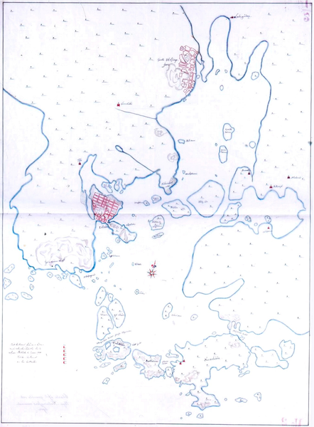
English: A very early map of Helsinki, Finland from 1645. The map shows both old Helsinki at the mouth of the Vantaa River as well as new Helsinki.
Suomi: Helsingin kartta vuodelta 1645. |
|||||||||
| Date | ||||||||||
| Source | Helsingin kaupunginarkisto | |||||||||
| Creator |
Hans Hansson (likely) |
|||||||||
| Permission (Reusing this file) |
English: The copyrights have expired and this image is in the public domain.
Suomi: Kartan tekijänoikeus vanhentunut. |
|||||||||
| Geotemporal data | ||||||||||
| Bounding box |
|
|||||||||
| Georeferencing | ||||||||||
Licensing
|
This work is in the public domain in its country of origin and other countries and areas where the copyright term is the author's life plus 100 years or fewer. | |
| This file has been identified as being free of known restrictions under copyright law, including all related and neighboring rights. | |
File history
Click on a date/time to view the file as it appeared at that time.
| Date/Time | Thumbnail | Dimensions | User | Comment | |
|---|---|---|---|---|---|
| current | 07:58, 8 August 2022 | | 1,353 × 1,836 (1.8 MB) | Tungsten | higher resolution |
| 09:36, 4 February 2013 |  | 466 × 632 (336 KB) | Tungsten | == {{int:filedesc}} == {{Information |Description= {{en|1=A very early map of Helsinki, Finland from 1645. The map shows both old Helsinki at the mouth of the Vantaa River as well as new Helsinki. }} {{fi|1=Helsingin kartta vuodelta 1645.}} |Source=Hel... |
File usage
The following pages on the English Wikipedia use this file (pages on other projects are not listed):
Global file usage
The following other wikis use this file:
- Usage on de.wikipedia.org
- Usage on fi.wikipedia.org
- Usage on pt.wikipedia.org