
File:Gulf of Mexico (MODIS 2018-10-19).jpg

Size of this preview: 731 × 599 pixels. Other resolutions: 293 × 240 pixels | 586 × 480 pixels | 937 × 768 pixels | 1,249 × 1,024 pixels | 2,499 × 2,048 pixels | 4,476 × 3,669 pixels.
Original file (4,476 × 3,669 pixels, file size: 1.46 MB, MIME type: image/jpeg)
| This is a file from the Wikimedia Commons. Information from its description page there is shown below. Commons is a freely licensed media file repository. You can help. |
.jpg)
Summary
| Description |
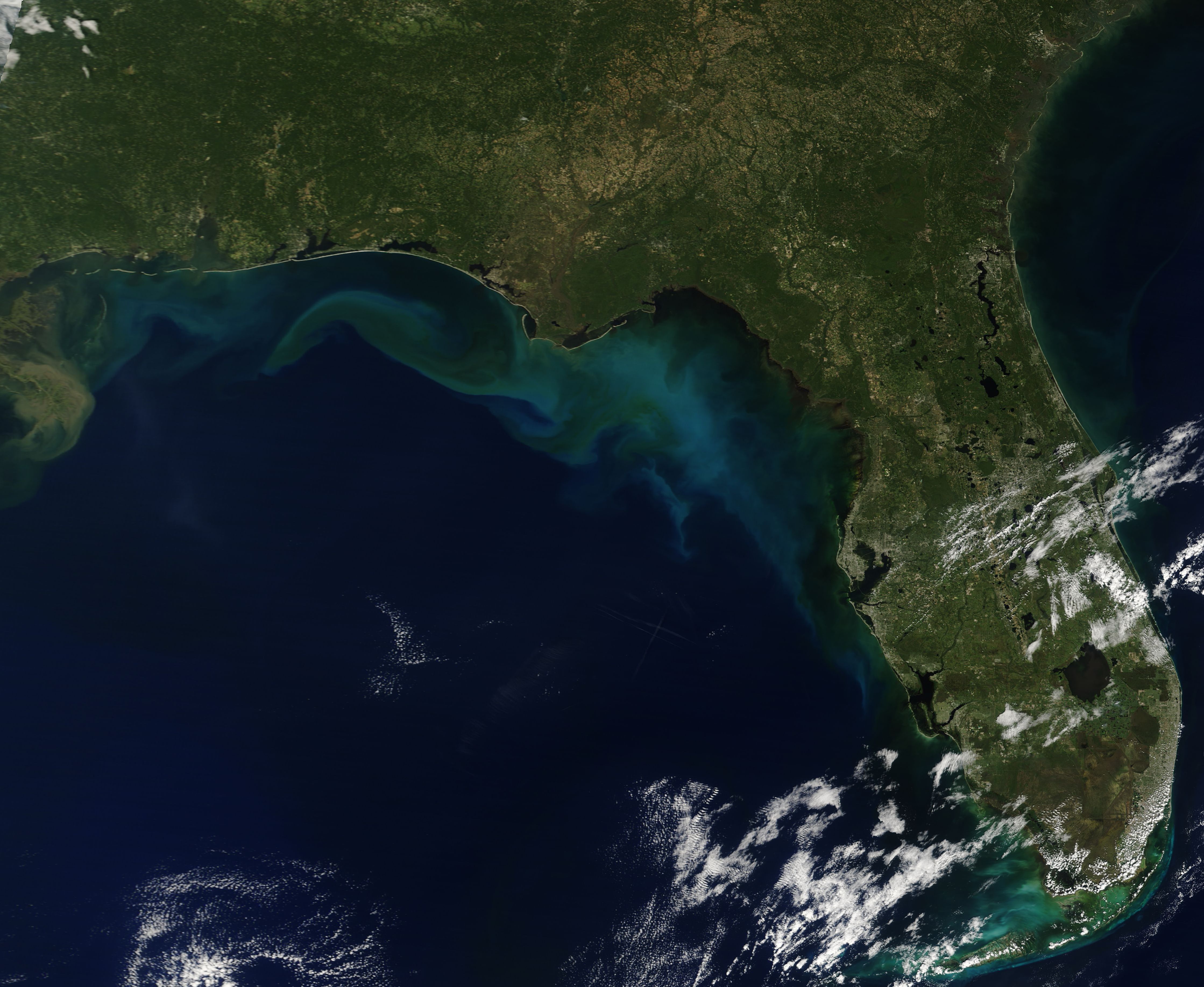
English: On October 10, 2018, Hurricane Michael struck the Florida Panhandle as a strong Category 4 hurricane with winds roaring at 155 mph (250 km/h). The winds caused significant devastation while rain and storm surge brought inundation and flooding to a wide coastal area. While the after effects of the hurricane were most obvious on land, the view from space confirms that the Gulf of Mexico also felt the wrath of Michael.
On October 13, NASA’s Aqua satellite passed over the Gulf of Mexico, allowing the Moderate Resolution Imaging Spectroradiometer (MODIS) on board to acquire a true-color image three days after the passage of Hurricane Michael. Large tan-and-teal discoloration marks seafloor sediment, river outflows, and coastal sediment washed offshore in the aftermath of Michael’s strong winds, storm surge, and wave action. A whorl of tan in the west part of the image floats south of Mobile, Alabama and appears to be entirely sediment. Some of the color - especially the milky-blue tones near the west coast of Florida - might also be due to phytoplankton. These are small plant-like microorganisms that live in the region year-round in small quantities and bloom in spectacular fashion when conditions are right. |
||
| Date | Taken on 13 October 2018 | ||
| Source |
|
||
| Author | MODIS Land Rapid Response Team, NASA GSFC |
| This media is a product of the Terra mission Credit and attribution belongs to the mission team, if not already specified in the "author" row |
Licensing
| This file is in the public domain in the United States because it was solely created by NASA. NASA copyright policy states that "NASA material is not protected by copyright unless noted". (See Template:PD-USGov, NASA copyright policy page or JPL Image Use Policy.) | ||
 |
Warnings:
|
File history
Click on a date/time to view the file as it appeared at that time.
| Date/Time | Thumbnail | Dimensions | User | Comment | |
|---|---|---|---|---|---|
| current | 01:26, 17 February 2024 | | 4,476 × 3,669 (1.46 MB) | OptimusPrimeBot | #Spacemedia - Upload of http://modis.gsfc.nasa.gov/gallery/images/image10192018_250m.jpg via Commons:Spacemedia |
File usage
The following pages on the English Wikipedia use this file (pages on other projects are not listed):
.jpg)