
File:Gas pipelines across Mediterranee and Sahara map-en.svg

Size of this PNG preview of this SVG file: 317 × 599 pixels. Other resolutions: 127 × 240 pixels | 254 × 480 pixels | 406 × 768 pixels | 541 × 1,024 pixels | 1,083 × 2,048 pixels | 832 × 1,573 pixels.
Original file (SVG file, nominally 832 × 1,573 pixels, file size: 3.78 MB)
| This is a file from the Wikimedia Commons. Information from its description page there is shown below. Commons is a freely licensed media file repository. You can help. |
Summary
| Description |
Deutsch: Karte der Gaspipelines durch das Mittelmeer und die Sahara: Trans-Sahara, Maghreb–Europa, Medgaz, Galsi, Trans-Mediterran und Greenstream.
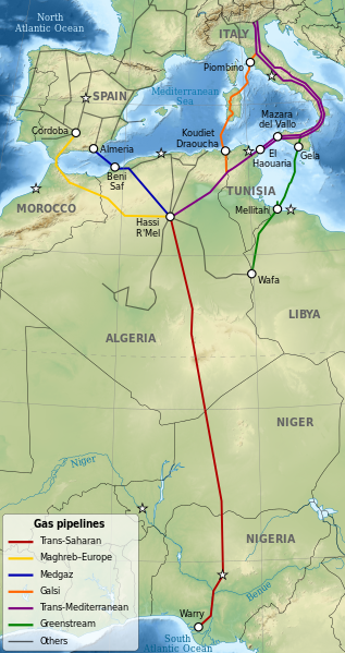
English: Map of gas pipelines across Mediterranee and Sahara: Trans-Saharan, Maghreb–Europe, Medgaz, Galsi, Trans-Mediterranean and Greenstream.
Español: Mapa de las gasoductos que cruzan el Mediterráneo y el Sahara: Trans-Sahara, Maghreb–Europa, Medgaz, Galsi, Trans-Mediterránea y Greenstream.
Français : Carte des gazoducs traversant le Sahara et la Méditerranée: Trans-saharien, Maghreb–Europe, Medgaz, Galsi, Trans-Méditerranéen et Greenstream.
|
||
| Date | |||
| Source |
|
||
| Author | Sémhur | ||
| Other versions |
| ||
| Attribution (required by the license) | © Sémhur / Wikimedia Commons / | ||
| SVG | W3C-validity not checked.
|
||
| Graphic Lab |


| Object location | | View this and other nearby images on: OpenStreetMap |
|---|
Licensing
I, the copyright holder of this work, hereby publish it under the following licenses:
| Copyleft: This work of art is free; you can redistribute it and/or modify it according to terms of the Free Art License. You will find a specimen of this license on the Copyleft Attitude site as well as on other sites. |
This file is licensed under the Creative Commons Attribution-Share Alike Attribution-Share Alike 4.0 International, 3.0 Unported, 2.5 Generic, 2.0 Generic and 1.0 Generic license.
- You are free:
- to share – to copy, distribute and transmit the work
- to remix – to adapt the work
- Under the following conditions:
- attribution – You must give appropriate credit, provide a link to the license, and indicate if changes were made. You may do so in any reasonable manner, but not in any way that suggests the licensor endorses you or your use.
- share alike – If you remix, transform, or build upon the material, you must distribute your contributions under the same or compatible license as the original.
You may select the license of your choice.
File history
Click on a date/time to view the file as it appeared at that time.
| Date/Time | Thumbnail | Dimensions | User | Comment | |
|---|---|---|---|---|---|
| current | 12:04, 3 October 2023 | | 832 × 1,573 (3.78 MB) | KajenCAT | File uploaded using svgtranslate tool (https://svgtranslate.toolforge.org/). Added translation for ca. |
| 14:34, 15 July 2009 |  | 832 × 1,573 (3.76 MB) | Sémhur | {{Information |Description= {{en|1=Map of gas pipelines across Mediterranee and Sahara : Trans-Saharan, Maghreb–Europe, Medgaz, Galsi, [[:en:Trans-Medi |
File usage
The following pages on the English Wikipedia use this file (pages on other projects are not listed):
Global file usage
The following other wikis use this file:
- Usage on ar.wikipedia.org
- Usage on be.wikipedia.org
- Usage on bg.wikipedia.org
- Usage on ca.wikipedia.org
- Usage on cs.wikipedia.org
- Usage on de.wikipedia.org
- Usage on el.wikipedia.org
- Usage on es.wikipedia.org
- Usage on fa.wikipedia.org
- Usage on fr.wikipedia.org
- Usage on fr.wikinews.org
- Usage on he.wikipedia.org
- Usage on it.wikipedia.org
- Usage on ja.wikipedia.org
- Usage on ka.wikipedia.org
- Usage on nl.wikipedia.org
- Usage on no.wikipedia.org
- Usage on ru.wikipedia.org
- Usage on sh.wikipedia.org
View more global usage of this file.