
File:Flickr - archer10 (Dennis) - Egypt-13A-085.jpg

Size of this preview: 800 × 600 pixels. Other resolutions: 320 × 240 pixels | 640 × 480 pixels | 1,024 × 768 pixels | 1,280 × 960 pixels | 2,560 × 1,920 pixels.
Original file (2,560 × 1,920 pixels, file size: 4.12 MB, MIME type: image/jpeg)
| This is a file from the Wikimedia Commons. Information from its description page there is shown below. Commons is a freely licensed media file repository. You can help. |
_-_Egypt-13A-085.jpg)
Summary
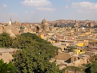
| Description | The city of the Dead , is a true curiosity, it is a cemetery, but also a city of the living. Originally, Cairo’s rulers selected the area for their tombs outside the crowded medieval city in a location that was mostly desert. However, dating back to early pharaonic times, Egyptians have not thought of cemeteries as places of the dead, but rather places where life begins. Hence, tombs were often thought of as places to entertain, and guest facilities for visitors were often appended to the tombs. So it came to be that squatters as early as the 14th century took up residence in the tombs, living easily alongside the dead. Cenotaphs are now used as tables and clothing lines are strung between headstones. Cairo, Egypt |
| Date | |
| Source | Egypt-13A-085 |
| Author | Dennis Jarvis from Halifax, Canada |
| Camera location | | View this and other nearby images on: OpenStreetMap |
|---|
_-_Egypt-13A-085.jpg¶ms=030.069093_N_0031.247863_E_globe:Earth_type:camera_source:Flickr_&language=en)
Licensing
This file is licensed under the Creative Commons Attribution-Share Alike 2.0 Generic license.
- You are free:
- to share – to copy, distribute and transmit the work
- to remix – to adapt the work
- Under the following conditions:
- attribution – You must give appropriate credit, provide a link to the license, and indicate if changes were made. You may do so in any reasonable manner, but not in any way that suggests the licensor endorses you or your use.
- share alike – If you remix, transform, or build upon the material, you must distribute your contributions under the same or compatible license as the original.
| This image was originally posted to Flickr by archer10 (Dennis) at https://www.flickr.com/photos/22490717@N02/2217521004. It was reviewed on 9 November 2012 by FlickreviewR and was confirmed to be licensed under the terms of the cc-by-sa-2.0. |
File history
Click on a date/time to view the file as it appeared at that time.
| Date/Time | Thumbnail | Dimensions | User | Comment | |
|---|---|---|---|---|---|
| current | 06:09, 24 July 2017 | | 2,560 × 1,920 (4.12 MB) | Leoboudv | original size |
| 11:31, 9 November 2012 |  | 1,280 × 960 (354 KB) | Matanya | == {{int:filedesc}} == {{Information |Description=The city of the Dead , is a true curiosity, it is a cemetery, but also a city of the living. Originally, Cairo’s rulers selected the area for their tombs outside the crowed medieval city in a location... |
File usage
The following pages on the English Wikipedia use this file (pages on other projects are not listed):
Global file usage
The following other wikis use this file:
- Usage on ar.wikipedia.org
_-_Egypt-13A-085.jpg)