
File:Distribution of the Slovincian language in the 20th century, in red.png
Size of this preview: 676 × 600 pixels. Other resolutions: 271 × 240 pixels | 541 × 480 pixels | 707 × 627 pixels.
Original file (707 × 627 pixels, file size: 73 KB, MIME type: image/png)
| This is a file from the Wikimedia Commons. Information from its description page there is shown below. Commons is a freely licensed media file repository. You can help. |
Summary
| Description |
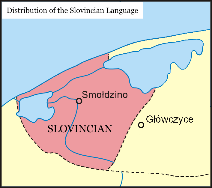
English: This map highlights the distribution of the Slovincian language during the 20th century. The map showcases the geographical areas where Slovincian was spoken, utilizing a vivid red color to emphasize its presence. Additionally, major cities in the region are marked, providing a helpful context for understanding the linguistic landscape. Dotted lines on the map delineate the extent of Kashubian dialects, offering further insights into the linguistic variations within the broader Slavic language family. This map serves as a valuable resource for researchers, linguists, and language enthusiasts interested in exploring the historical spread and significance of the Slovincian language in the 20th century. |
| Date | |
| Source | Own work |
| Author | Grassfuel |
Licensing
I, the copyright holder of this work, hereby publish it under the following license:
This file is licensed under the Creative Commons Attribution-Share Alike 4.0 International license.
- You are free:
- to share – to copy, distribute and transmit the work
- to remix – to adapt the work
- Under the following conditions:
- attribution – You must give appropriate credit, provide a link to the license, and indicate if changes were made. You may do so in any reasonable manner, but not in any way that suggests the licensor endorses you or your use.
- share alike – If you remix, transform, or build upon the material, you must distribute your contributions under the same or compatible license as the original.
File history
Click on a date/time to view the file as it appeared at that time.
| Date/Time | Thumbnail | Dimensions | User | Comment | |
|---|---|---|---|---|---|
| current | 18:14, 21 May 2023 | | 707 × 627 (73 KB) | Grassfuel | Uploaded own work with UploadWizard |
File usage
The following pages on the English Wikipedia use this file (pages on other projects are not listed):
Global file usage
The following other wikis use this file:
- Usage on gl.wikipedia.org