
File:Bridge 98, Lancaster Canal - geograph.org.uk - 1773863.jpg

Size of this preview: 449 × 600 pixels. Other resolutions: 179 × 240 pixels | 479 × 640 pixels.
Original file (479 × 640 pixels, file size: 195 KB, MIME type: image/jpeg)
| This is a file from the Wikimedia Commons. Information from its description page there is shown below. Commons is a freely licensed media file repository. You can help. |
Summary
| Description |
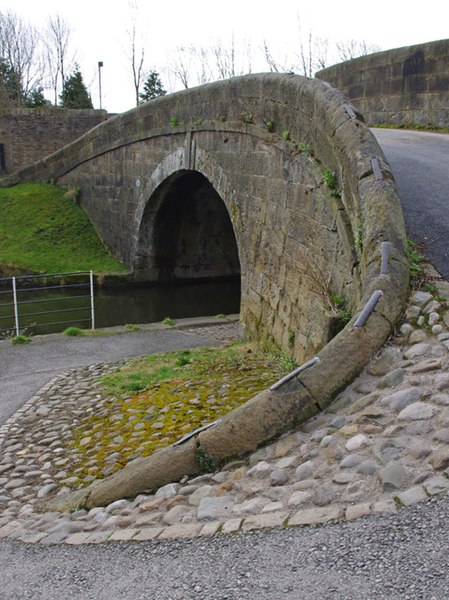
English: Bridge 98, Lancaster Canal. Basin Bridge, originally linked the canal depot with Aldcliffe Road and carried the tow-path across the canal, presumably to keep it clear of the wharves on the north side of the basin. The roving bridge design allowed the horses to cross over without untying the tow-rope. Presumably, the metal "staples" linking the coping stones prevented the tow-rope catching in the mortar between the stones. The bridge now forms part of the Lancaster cycle network. (See 1614603 for a more conventional view.) |
| Date | |
| Source | From geograph.org.uk |
| Author | Ian Taylor |
| Attribution (required by the license) | Ian Taylor / Bridge 98, Lancaster Canal / |
| Camera location | | View this and other nearby images on: OpenStreetMap |
|---|
_heading:180.00&language=en)
| Object location | | View this and other nearby images on: OpenStreetMap |
|---|
_heading:180.00&language=en)
Licensing

|
This image was taken from the Geograph project collection. See this photograph's page on the Geograph website for the photographer's contact details. The copyright on this image is owned by Ian Taylor and is licensed for reuse under the Creative Commons Attribution-ShareAlike 2.0 license.
|
This file is licensed under the Creative Commons Attribution-Share Alike 2.0 Generic license.
Attribution: Ian Taylor
- You are free:
- to share – to copy, distribute and transmit the work
- to remix – to adapt the work
- Under the following conditions:
- attribution – You must give appropriate credit, provide a link to the license, and indicate if changes were made. You may do so in any reasonable manner, but not in any way that suggests the licensor endorses you or your use.
- share alike – If you remix, transform, or build upon the material, you must distribute your contributions under the same or compatible license as the original.
File history
Click on a date/time to view the file as it appeared at that time.
| Date/Time | Thumbnail | Dimensions | User | Comment | |
|---|---|---|---|---|---|
| current | 22:36, 11 March 2011 | | 479 × 640 (195 KB) | GeographBot | == {{int:filedesc}} == {{Information |description={{en|1=Bridge 98, Lancaster Canal Basin Bridge, originally linked the canal depot with Aldcliffe Road and carried the tow-path across the canal, presumably to keep it clear of the wharves on the north side |
File usage
The following pages on the English Wikipedia use this file (pages on other projects are not listed):
Global file usage
The following other wikis use this file:
- Usage on ar.wikipedia.org
- Usage on es.wikipedia.org
- Usage on he.wikipedia.org
- Usage on id.wikipedia.org
- Usage on www.wikidata.org